Overlooked

Something I always seem to forget when I haven’t been backpacking in a while is just how badly I sleep.  At first, I thought it was about equipment.  I gave up on the ultra-light sleeping pad and invested in a Big Agnes inflatable mat.  That was a nice upgrade.  A big, thick, insulated, cushy air mattress that really didn’t weigh a whole lot more.  I still didn’t sleep well.  There are several factors involved:

  1. Noises.  These range from bears to my husband snoring (he claims it’s me), but there always seem to be noises I can’t ignore.
  2. Fluids.  I drink a lot of water when we’re hiking.  Unfortunately, particularly in cold weather, this leads to having to get up many times in the middle of the night.  The whole process of managing getting out of the tent and then wandering out into the cold and/or rain has a pretty significant impact on sleep.
  3. Discomfort.  Backpacking uses muscles that don’t get used while sitting at a desk all day.  They don’t even get used in yoga class, rowing, biking, or the gym.  These muscles start screaming as I struggle to find a good position for my head.  At home, I sleep with two pillows to keep my neck and lower back comfortable.  Perhaps I need to find light-weight pillows for backpacking.
  4. Time Shift.  When one backpacks, there is little to do at the campsite after dinner if there’s no fire.  We rarely have a fire.  In many places, it’s not allowed.  In places where it is allowed, it’s often a lot of work.  Sometimes, it’s just impossible.  For example, when it’s pouring down rain.  So, once dinner is over, the dishes are washed, teeth are brushed, the supplies are appropriately stowed, and fatigue from the many miles of hiking sets in, it’s bedtime.  When bedtime is very early, this contributes to waking up throughout the night.

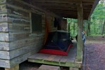
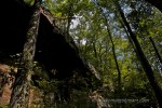
Rain suddenly pounding on the metal roof above our tent caused noise issues.  No pillow and sharing a tent with both a man and a dog created discomfort issues.  Going to bed at 7:30PM contributed to time shift issues.  The only thing I did well was taper off on water consumption.  None-the-less, I felt like I’d gotten no more than 15 consecutive minutes of sleep all night.

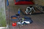
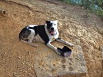
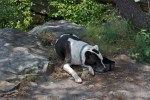
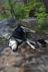
I think Tisen felt the same way–he wouldn’t get out of the tent in the morning.

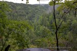
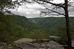
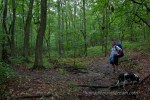
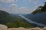
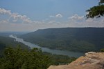
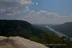
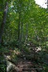
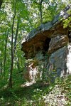
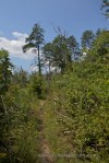
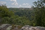
But, we made it back on the trail eventually.  On the way back, we discovered Tommy Overlook, a highlight of the trail we’d missed in the heavy rain the day before.  We were making good time on the trail–all of us walking double-time in some unspoken agreement that we wanted to get home as fast as possible.  We stopped for a good 15 minutes to enjoy the view of the 3 gulches converging.  I couldn’t help but imagine what it would look like in a few weeks when the trees are in color.

The Next 6.3 Miles

Mentally embracing the rain, we started down the trail, determined to make it the next 6.3 miles to a place called “Hobbs Cabin.”  We couldn’t help but hope the cabin (a rustic, first-come, first-serve arrangement) was available.

After about 10 minutes of hiking in the downpour, we realized hiking in the rain on a hot day was quite pleasant.  Instead of feeling stinky and sticky with sweat, we felt cool and refreshed and there were no bugs while it was raining.

Tisen, on the other hand, was not so enamored with the feeling of cool rain. He did his best to walk underneath the overhang of our packs to try to avoid being rained on directly.  He ended up just as wet as the rest of us, but there must have been something comforting about feeling like he had a roof over his head.

When we got to the first overlook of the “gulf”  (apparently that’s what a gulch is called in Tennessee), the rain had taken a break.  The sky was overcast and it was hard to tell it was noon.  The break in the rain was nice, as was the breeze blowing up from the valley below.  But, alas, we were trying to cover 6.3 miles before it got too late in the afternoon, so we couldn’t stop long to enjoy it.

As the trail veered away from the edge of the gulch, we re-entered the woods, and perhaps a time from the past.  It was easy to imagine the first settlers finding their way through woods like these when such woods covered much of the Eastern US. Of course, they would have all be old-growth forests back then.  But, these woods, mostly free of invasive plants, made me feel like we’d been transported in time. Thankfully, our gear wasn’t transported back to historical equipment–I think we would have needed a wagon.

At long last, we arrived at Hobbs Cabin and were relieved to find it unoccupied.  A tiny, dark, uninviting shelter, it was equipped with 6 bunks and a table fastened to the wall.  The bunks were wood planks that would require sleeping pads and bags to make comfortable.  The small windows on the back wall let in so little light that even with our flashlights, we had trouble seeing inside the cabin.  I had a hard time imagining spending the night in there.

I proposed we pitch the tent on the front porch, screening out all insects, putting us where we were sure to get a breeze, and under a great big roof to keep up out of the rain.  We hung the rain fly in position just in case we started to get wet, but planned to sleep under just the screen for the night.  Tisen was more excited than a child to crawl into the tent with us, even though we decided to call it a night around 7:30PM.  It was the earliest we’ve ever gone to bed.

Sunless in Seattle

I love flying over Seattle.  There’s almost always clouds below the plane, blanketing the sky.  Then, suddenly, the peak of a mountain pops through like a giant whitehead.  Only an attractive one.  Mt Rainier particularly stands out.  Perhaps because it’s so rarely been visible from the ground on any of my trips to the area.

These photos are from the first time I went to Seattle, which wasn’t until 2004.  We went to visit some friends who had moved out there from Columbus.  We spent most of our time North of Seattle, but we decided to spend the last day of our trip downtown, exploring the city.

The Experience Music Project and Space Needle were two of the sites on our “must see” list.  Since they were co-located, it was pretty easy to work them both into our schedule.  As luck would have it, we had beautiful blue skies and sunshine that entire trip until the day we went into downtown Seattle.  I don’t know if this is because there is some sort of vortex over Seattle and causes it to be cloudy and rainy there all the time or if the maximum number of sunny days had been reached and the clouds were turned back on.

As we approached the EMP Museum, it looked mostly like a sheen of gray against a gray sky, drenched in gray mist.  We were happy to go inside.

Seeing the collections of guitars was pretty exciting to my husband.  A little less so to me.  But, the tornado of guitars was pretty impressive.  In truth, there could have been absolutely nothing inside that building and I could have spent the entire day trying to figure out how to shoot its strange curves and intersecting angles.  Armed only with my PowerShot G3 at the time, I struggled with the lighting conditions for starters.  But more than that, trying to find a logical edge to decide on what to include and exclude from the frame seemed impossible as each shape flowed into the next.  Each attempt at framing a shot seemed like I was cutting off the flow.  Most of my shots are not even interesting enough to include with this post.

After exploring the interactive exhibits in the EMP, we made our way over to the Space Needle.  In spite of he rain, the view was pretty impressive.  We looked straight down on the EMP and got to look at the shape of tis exterior.  We also got a clearer view of how colorful the exterior really is.

The Space Needle also afforded some great looks at the ports below.  Down in the park below, a group of kids were playing with giant water canons permanently mounted there.  I found it amusing that they were squirting each other with water while it was raining.

By the time we’d stood out on the observation deck for 10 minutes, we were both looking like drowned rats.

White Plains

Back a few years, which now seems like a lifetime ago, I used to go to White Plains, New York for work on a fairly regular basis.  There are several things I recall about White Plains, NY.  First, if you ever have to go there and someone suggests you should fly into LaGuardia or Newark, just say no.

The first time I went there, I flew into Newark on a Sunday and spent 3 hours trying to get across one bridge–there are really only 2 bridges to choose from when coming from Newark to White Plains and apparently the entire world is divided between those two bridges on a Sunday afternoon.

My second trip, I flew into LaGuardia and my transit time was cut to about an hour and a half.  On my third trip, when I arrived in Cleveland and ran for my connection, arriving at the gate all flushed and flustered just after the door closed, the gate agent asked me where I was going.  Not thinking, I replied, “White Plains.”  She looked at me and said, “The flight to White Plains is at that gate,” pointing at a gate across the aisle.  I managed to switch flights in time to go to White Plains.  When I arrived, I discovered that airport was exactly 8 minutes from the customer site I was visiting.

I asked the customer why they had recommended Newark or LaGuardia.  They’d assumed I wanted a direct flight.  They didn’t realize that I had to connect pretty much anywhere I flew to.  Still, I haven’t figured out why someone would think it was better to have a direct flight and a 3 hour drive (or even an hour and a half drive) than to have a connection and an 8 minute drive.  Even if I had an hour and a half layover, it’s more productive than an hour and a half sitting in traffic.

White Plains itself is quite beautiful.  Like most of the parts of New York I’ve been to (other than New York City), you see more trees than buildings.  Everything is cloaked behind stands of evergreens.  It’s hard to even tell when you’ve arrived at an office park.

For the less nature-centric, there is also good shopping, good food, great access to planes, trains, and any other imageable form of transportation (including horses, although I think they were all privately owned).  Just don’t try to drive there.

I had the rare pleasure of spending an evening alone with my camera on one of my trips to White Plains.  I made an exploratory pass around the neighborhood and found a lovely Spanish restaurant on the shore of the Hudson along with a park.  After filling my belly, I walked along the dock, taking pictures of the scenes on the river.

What was most surprising to me was the view of New York City.  Looking down the Hudson, Manhattan spread itself across the river like a bridge in the distance.

Moon Meetings

Rushing to catch the full moonrise, I turned the corner onto Market St and got my first view of the horizon, a thin line of orange glowing just over the tree tops.  I started running again.  By the time I got far enough across the bridge to have good angle, the orange glow had disappeared.

I got my camera set on the tripod, got focused on the bridge, and waiting.  Then I waited more. About the time I got tired of waiting and decided to swing the camera around to shoot the sunset until the moon appeared, I saw a movement out of the corner of my eye and about jumped into traffic with surprise.  A man apologized for scaring me and then said something about my camera.  I smiled and he smiled back and then he walked away.  I have no idea what he said, but apparently a smile was an appropriate response.

Moments later, another man showed up.  This one with a camera in hand asking me if I knew where the moon would rise tonight.  I told him about the orange glow I’d seen.  He told me that he was the architect for the current, restored version of the Walnut St bridge and he’d been wanting a picture of the full moon rising over the bridge for years.

We waited together for the moon to reappear.  Eventually, I spotted another band of orange glowing through the heavy clouds.  We both started shooting like mad.

He wanted a very specific image with the moon centered over a pier of the bridge (or whatever it’s called).  I was hoping more for images with people in front of the moon.  Unfortunately for me, the moon was too high by the time it appeared from behind the clouds for anyone to be in front of it.  I lined up behind my new acquaintance and shot over his head as he bent over the rail of the Market St bridge in front of me.

Eventually, the architect’s wife pulled up in a car, pulling over in heavy traffic just long enough for him to jump in.  I was left to continue shooting on my own.  I shot as wide as my lens and teleconverter would allow, fascinated by the reflection of the moonlight on the water.

Then, another car pulled over.  A third man asked if I could send him some photos–he and his wife were trying to take pictures of the moon with a cell phone.  I asked if he had a card and his wife, apparently hidden in the back seat, leaned forward with a car from a vineyard in Ringgold, GA.  The man said, “Send us a picture and we’ll send you a bottle or wine!”  I wondered how good my picture had to be for a bottle of wine.

It’s funny how people seem to assume you’re going to get a great image when you’re shooting with a long lens.

The Last Push

After spending some time cooling in a stream, Tisen and I make the final push home from Edward Point.  We make it to the first place we got lost on the way out.  When we get there, it’s completely obvious that a lower trail completely avoids the downed trees that caused us so much trouble on the way out.  We make it around the whole area with only one lift for Tisen in a spurt of steep rock steps.  I cannot resist looking to see if the trail was obvious from the other side.  It was not.  I have an excuse for at least one of my wrong turns.

I’m almost afraid to stop again.  Tisen is moving well and looking energetic.  I’m moving well now that we’re going uphill, my knee only complaining when we go downhill.

We make it back to the first natural overlook and I know we’re home free.  We take a break there, just to be safe.  Tisen looks at me with an expression on his face that I swear says, “Yay, Mom!  Look at us!  We’re almost back!”  Who knew a bit bull could look like a cheerleader?

A couple pauses to take a few quick shots from the overlook while we gather our energy for the last push.  The trees start rustling, the sun disappears, rain drops start to fall.  I realize I have nothing to cover my camera with and hope that it doesn’t get too wet.

I text Pat and let him know that we have survived and are on our way home.  I had updated him earlier when we were lost–one of the advantages of hiking on Signal Mountain is that you still have a signal.  🙂

When I start packing up Tisen’s water, Tisen pops up like he’s been waiting on me all along.  I smile.  I don’t know if he remembers what the last part of the trail is like, but it involves a lot of jumping up onto high steps and rocks to get back to the manmade overlook at the parking lot.  It’s a lot to ask of a tired dog.  I prepare myself for the possibility of having to lift Tisen many times in the last quarter mile.

Tisen springs up every rock and step like a young pup.  He is clearly excited to be getting closer to home.  He charges ahead when I pause.  When he’s behind me, I have to be careful not to kick him as I step, he’s so close on my heels.

We make it to the park.  We make it up the final hill to the car.  Tisen catapults himself into the back seat and lies there panting.  I rush to change my shoes so I can get us moving.  The breeze is still blowing, cool and slightly damp, although the rain has stopped.  I smile to myself as I put the car in drive:  we finally made it to Edward Point.

Blazing Trails

After allowing Tisen a 20 minute nap at Edward Point, I decide we’d better start working our way down.  With our side-trips on the way up, we’re an hour behind schedule and we’ll be two if it takes as long to get back.

Unfortunately, the sun is now higher, the temperature hotter, and the bugs swarming more energetically.  I’m not sure if it’s the heat or the bugs that get to Tisen, but not more than a 1/4 mile from Edward Point, he finds a shrub, runs into the shade underneath, and starts digging himself a nest in the dirt.  It takes quite a bit of coaxing to get Tisen back out into the sun.

Fortunately, we are back in the shade a little further down the trail.  And the turkey vultures who greeted us on the way up have given up on us dying, disappearing down the river valley.  I took that as a positive sign.

Because I had opted to break in my new hiking boots in anticipation of a back-packing trip the following weekend, my knees were suffering.  My left knee was the first to start screaming.  This has something to do with inflammation.  As my knee starts to swell, it no longer wants to bend.  When I bend it and step downhill, a sharp stabbing pain shoots through the joint.  It makes going downhill excruciating.  I make a mental note to make sure I figure out how I can carry my camera and still use my trekking poles before we set out backpacking next weekend–I imagine my knees won’t hold up to a backpack without trekking poles.  I wish I could wear my fivefinger shoes, but the rocky terrain and the extra weight of a backpack is a bit much for almost-bare feet.

We manage to stay on the right trail on the way back.  I am watching for blazes with the intensity of a pit bull.  Or maybe that’s Tisen?  When we get to the juncture where I went the wrong way on the way up, I look back to see how I got confused.  I realize there is no excuse for missing the main trail.  The blazes are obvious and well-placed.  I don’t know what I was thinking.

We keep on stepping, slower than I’d like, but we’re making more progress than if either my knee or Tisen gives out completely.  I have to lift Tisen over some big rocks in the part of the trail we missed on the way up.  While I’m glad I’m able to lift him, I am simultaneously worried about how much poison ivy he’s run through and how much of it each lift is getting on me.

We make it back to water.  Tisen plows in and lays down.  I watch and wait for him to look cooled and refreshed so we can continue on our way.

Edward Point

As Tisen and I walked what we thought was the last 15 minutes to Edward Point, shadows raced across the forest floor like silent, dark ghosts.  I looked up to discover a half a dozen turkey vultures circling overhead.  Close overhead.  Too close.

Given we were hot, tired, and bleeding from numerous wounds from brambles, it was a little ominous to feel like they were so interested in us.

Fortunately, they soared further away as we approached, giving us a more breathing room.

As we looked around (well, I looked around, I don’t know what Tisen was doing exactly), I realized that the area must have had a fire in recent years.  The trees were charred in place.  The growth was thick and dense, but it was all wild flowers and sun-loving brush.  The bugs loved it.  I couldn’t seem to keep them off of me.  I saw bugs on me that I’d never seen before.  I stopped shooing and started swatting, leaving red hand-prints on my arms.  They went well with the bleeding scratches from the earlier brambles.

There is something disconcerting about hiking from relatively deep forest into bright meadows when a mountain is well below timberline.  You expect to come out into open spaces when hiking in Colorado, but here, it just seems wrong.  I found myself wondering when the forest had burned and whether that was normal here in the Eastern  US.

About 15 minutes after we’d found our way back to the Cumberland Trail, we encountered an overlook that faced the cliff on the other side of the gulch.  Directly across from us was a huge building that absolutely looked wrong.  There is nothing I resent more than when I spend hours making my way to a overlook in the “wilderness” only to discover I’m within a football field (or two) of a major development.  I found myself hoping this was not, in fact, Edward Point.

I googled Edward Point to see if I could tell.  Thankfully, I was able to determine that we were not there yet.  Now, I had a decision to face.  A 72-pound dog who is tired and hot and 45-year-old knees that are equally tired give one pause at moments like these.  Had it been me and only me, there would have been no hesitation–I was going to make it to Edward Point this time no matter what.  However, I’d lifted Tisen enough times on the way up to know I couldn’t carry him back.  I had to consider whether he could make it or not.

I decided to give it another 10 minutes.  I could see where we were along the gulf and it seemed like Edward Point, which overlooks the main river valley, had to be close.  I was so glad we’d stuck it out when we arrived at the overlook.  While Tisen took a nap in the shade, I took as many photos of the view as I could.

Lost Again

Tisen has a very specific way of cooling off in streams. He walks in, feels around with his feet until he finds the perfect spot, then he lays down.  I suspect it has something to do with his Holstein genes.

Having cooled off for several minutes and drunk his fill of water, Tisen recovered enough to tackle the uphill climb.

As we made our way of the far side of the gulch, the climb got steeper.  We were distracted by the amazing rock formations.  Perhaps this is why, when we got to the next junction in the trail, I decided we needed to head downhill rather than up.  This turned out to be a bad mistake.

We ended up on a trail that kept getting narrower and more overgrown.  Soon, we were walking through brambles that hooked themselves into bare skin, tearing flesh as I forced my way through.  Tisen was somewhat protected by his fur, but both of us looked like we’d taken a beating by the time we got to a clearer part of the trail.

The trail now tucked up against another rock bluff, looking more like a deer trail than a parks and recreation trail.  I should have turned around about a 1/4 mile in.  Have I mentioned I have issues with going backwards?

On the plus side, since nature was calling pretty loudly at this point, it was good that we were in an isolated area with plenty of underbrush so I could heed the call without fear of someone walking up on me.  On the minus side, there were so many enormous spider webs in the rocky bluff I was almost afraid to turn my back on them.

When we got around the bluff, we started bush-whacking uphill, hearing voices above us and thinking that must be the main trail.

This was tough going.

Not only were there more brambles and spider webs, but now there were more and more rocks to climb as well.  I was worried about Tisen getting a little more exercise than he could handle.

As we walked along the face of yet another rock bluff, we caught up with a couple with a child and two dogs.  I have no idea how they all got there, but there they were.  I asked them where we were and they assured me that we were just below the Cumberland Trail.  All we had to do was go straight up the rock face.

I found an entry point that I could climb, lifted all 72 pounds of Tisen up onto the rock at shoulder height and managed to convince him to stay up there while I used a tree to assist my own ascent.

Bush-whacking through another patch of brambles rewarded us with being back on the main trail.  The couple had said Edward Point was about 15 minutes away; had it been much further, I probably would have started heading home.

Beyond the Overlook

Continuing our hike from Signal Point to Edward Point, Tisen and I made our way along the steep slope of the gully.

I guess it’s a gully.  I’m not really clear on when a gully becomes a canyon or if there’s some other name for a horse-shoe-shaped space in the side of a mountain, but essentially, we were going to hike in nearly an ellipse, but we were going to end up on a point on the opposite cliff from where we started.

The trail starts high, goes mostly downhill to the midpoint and then climbs again to Edward Point overlook on the far side.  It requires stepping over, on, or around many rocks in the process.  We clambered our way up the trail, keeping a pretty good pace going.  I eyed the poison ivy growing along the trail with disdain–I knew it meant Tisen and I were going to be taking very thorough baths that night.

When we got about another 1/2 mile down the trail, we ran into an impasse.  This happens quite frequently on trails.  A tree has fallen across the trail that can’t be gone over, so you have to go around.  Usually, this might mean walking a 1/10 of a mile out of the way to skirt the fallen tree.  In this case, there were dozens of trees that had fallen.  It was a terrible scene of destruction that made me sad.  On the other hand, with as many bad storms as have rolled through this area in recent years, it’s pretty amazing that that’s all the damage that’s been done.

But there were piles of fallen trees.  And we we tried to go around, we ran into only more fallen trees.  We went around and went around some more, trying to find a route through all the crap that fell with the trees.  Eventually, we did make it.

Of course, in the process, I lost the trail.  We ended up bush-whacking our way back to the trail, arriving slightly scratched and a little more tired than we would have otherwise.

When we finally found the main trail again, we hadn’t gone more than 10 feet hen we saw a junction with a trail that came from the same direction we had just come from.  It was clearly blazed as the main trail and it looked like it would have missed all of the fallen trees.  I kicked myself and wondered how I had missed that option when we took the high trail to hell.

But, back to relatively clear sailing, we continued on our way, making it to the point where we’d turned around the first time we tried to hike this trail and pushing beyond.  Less than a 1/4 mile past our previous turn-around point, we ran into a stream.  Tisen made quick work of laying down in the water to cool off.  I thought about joining him, but there wasn’t a puddle big enough.