Being Moderate

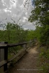
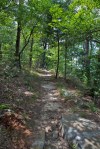
At the New Life Hiking Spa, everyone gathers outside the front door and the staff announces the hikes each morning.  They’re categorized into “Nature Walk,” “intermediate,” and “Advanced.”  The Nature Walk being mostly flat, a non-challenging surface to walk on (like a gravel road), and only about 4 miles or so in distance.  The Intermediate walks have more ups and downs, and may require a little scrambling over rocks.  The Advanced hikes are more vertical and are on “unimproved” trails.

While I might have opted for the Advanced or Intermediate hikes, I was there more for the company of my friend and less for the physical challenge, so I was more than happy to do the nature walk.  Plus, I wanted to shoot and I figured I’d have more opportunities on the nature walk than on an advanced hike.

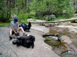
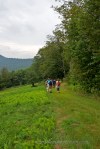
This happened to be the day for the most difficult Nature Walk of the week.  It had a long, slow climb in the middle of it.  This worked to my advantage.  I got to take my time shooting because the group wasn’t moving as fast as they would have been on a flat trail.  I had time to shoot and then run to catch up to my friend.

This was even more perfect than I realized at first.  I got a great workout by running hard to catch up (when I say running hard, I mean any attempt to run on my part is hard–I don’t run fast or far or at all if I can help it).  We would walk along together chatting until the next photogenic subject appeared.

I would have hated being on an advanced hike and feeling like I was holding other people up every time I stopped for a shot.

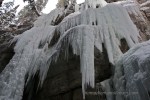
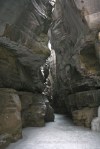
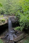
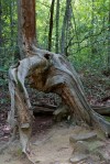
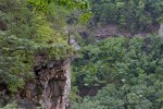
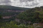
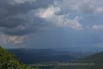
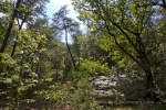
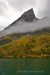
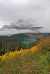
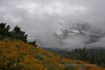
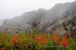
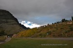
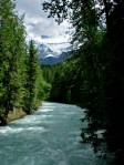
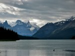
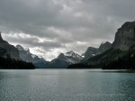
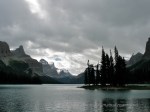
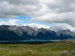
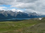
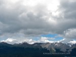
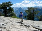
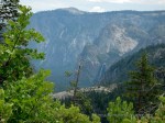
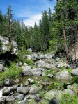
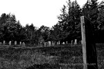
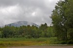
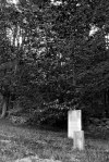
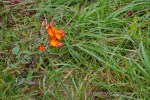
Plus, the road we walked was lovely.  We were afforded many views of the mountains and lots of pretty open fields full of wildflowers.  The only slightly traumatic part was the graveyard near the beginning of the walk.  We had to wonder what kind of message they were sending us by not only walking us past the graveyard on the way out, but stopping there for our snack break on the way back.  I loved it for the photographic opportunities it provided, but it’s a little odd to snack amongst the dead.

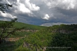
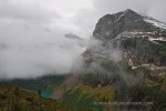
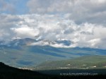
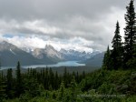
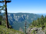
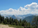
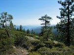
We extended the hike by going past the trailhead to another trail that led up a hill to a lovely view of the valley below and mountains in the distance.  One of our fellow hikers was starting to worry us with his heavy breathing, profuse sweating, and red face.  It was hard to believe the hike was that much of a workout for anyone, but it was a pretty good uphill, I guess.  We were concerned he had heat stroke.  In the end, he, along with the rest of us, did survive and we left no one in the graveyard.

Ice Walk

I find myself searching for photos of frozen things.  These are from a guided hike we did in the Maligne Canyon our first day out in Jasper on a winter trip a few years ago.

When the temperature is dropping to -25 fahrenheit, what better way to spend the day than touring ice formations?

We were nervous about our first hike in those temperatures–we weren’t sure we’d be able to stay warm in a group hike where we were constrained to the pace of the slowest hiker.  I decided to layer up.

I take layering very seriously.  For anything less than -10, if I’m not going to be moving quickly, this is my tried and true approach:

Layer 1:  quick-dry undergarments, including a long-line bra top that adds warmth all the way to my waist.

Layer 2:  panty hose

Layer 3:  silk long underwear, top and bottom

Layer 4:  Sock liners

Layer 5:  Under Armor for very cold weather top and bottom

Layer 6:  Wool long underwear top and bottom

Layer 7:  Fleece top and bottom

Layer 8:  Waterproof pants and heavy wool socks

Layer 9:  Down sweater up top

Layer 10:  Waterproof shell

To Top it All Off:  A very sexy balaclava with a super thick wool beanie over it.

Add waterproof snow boots with HotHands toe warmers, windblocker glove liners and a pair of waterproof down mittens and I’m ready to roll.

The most difficult part of all these layers is getting into them without breaking into a sweat.  Usually, I’ve soaked through layers 1-6 by the time I get to layer 8 and I have to carry layers 9 and 10 outside with me to cool off before putting them on.

The second most difficult part is walking.  If you have ever seen the moving “A Christmas Story” with the classic scene of the kid so bundled up that when he falls over, he is stuck on his back waving his arms and legs like an over-turned turtle, that’s what I feel like when I dress for really cold weather.  In truth, technology is pretty amazing these days so each layer is impressively thin for the insulating factor and I can walk pretty well.

I eschew cotton because of the sweat factor.  Cotton loses its insulating properties when it gets wet.  With fabrics that keep me warm even when they’re wet, I worry less about wearing too many layers.

Right at the moment, I’m looking out the window at heat lightning flashing in the sky and wondering how on earth I got from thinking about ice to thinking about wearing 10 layers of warm clothes.  The last thing I’d want right now is an extra layer.

But in Maligne Canyon, among the giant ice formations, I was perfectly warm with the cold air against the only exposed skin on my face, content to stand with my mouth wide open in amazement, blowing out clouds of frost with each breath.

In Lieu of Backpacking

We are trying to get a hike in at least once a weekend.  Since it’s a big reason we chose to move to Chattanooga, we figured we ought to take advantage.  However, the hot and humid August weather has made hiking slightly less enticing.

I did a little research to pick a place to hike that wasn’t too far away.  I learned about South Cumberland State Park and the Savage Gulf State Natural Area, located inside the park.

There was a 17 mile hike that sounded intriguing, but 17 miles for us means spending the night.  Since I had a lot going on this past week, we didn’t have time to prepare for backpacking.  Plus, we weren’t quite sure where Tisen would sleep given that our 2 person tent is really only big enough for a person and a half.

So, we opted to do two short day hikes instead.

We headed out Saturday morning loaded down like we were spending the night after all (the joys of too much photography equipment).

When we arrived at the Stone Door ranger station, we saw a sign that said Laurel Falls was only 250ish yards from the parking lot.  So, of course, we had to walk there first.  What they didn’t mention was that it was 250 yards down a bunch of stairs and 250 yards back up those stairs.  But, still, who wouldn’t go 250 yards to see a waterfall?

I’m not sure how excited Tisen was about the waterfall after the stairs, but he made it and I was happy I had my tripod so I could shoot with long exposures, creating smooth water.

We headed back up the steps and on towards Stone Door from there.

The walk to Stone Door started on a paved path.  Paved as in asphalt.  We noticed blazes on the trees marking the trail and Pat commented that he was glad they’d marked the trail because otherwise we might have gotten lost.  It did seem a bit odd to hang metal trail blazes on the trees along a trail that was paved, but I guess they haven’t lost anyone yet.

The first overlook was the end of the asphalt, thankfully.  Although, we passed a woman coming back the other way with only one leg.  I don’t know if she was able to walk on the unpaved portion of the trail or not, but it did make me appreciate the asphalt.

From the overlook, we not only got a nice panoramic view of the mountains, but we spotted a rocky outcropping in the general direction we were headed.  We suspected it was our destination.

Tisen was not any more excited by me setting up my tripod at the overlook than when I pulled it out at Laurel Falls, but he waited fairly patiently once Pat took him off the asphalt and into the shade.

If there was one thing that would have made the day nicer, it would have been cooler temperatures and less humidity.

Monkey Feet

It all started on the hike to Grinnell Glacier in Montanna.  Pat and I were working our way up the mountain trail with me in my hiking boots that felt like giant led-filled balloons when we passed a couple on their way back down.  They looked impossibly fresh.  They weren’t limping.  They looked relaxed and comfortable.  As I looked down to find footing, I noticed their feet.  Low and behold, they were wearing fivefingers shoes.  I had heard of fivefingers before, but it hadn’t occurred to me people would wear them on the trail.

After limping our way back at the end of the hike with me barely able to put weight on my knees and hips, I found myself wanting to try fivefinger shoes.

When we got home, I bought a pair like the ones we saw on the trail–black neoprene.  Although I didn’t give them a true trail test for many months, they turned out to be a miracle on the treadmill.  My knees and hips felt better than they’d felt in years after the initial adjustment period.

There definitely is an adjustment period!  A whole bunch of tiny muscles in my feet and ankles had to be reborn and developed before I could walk as fast or as far as I had been walking.  But, once I’d adjusted my stride and footfall and developed weakened muscles, I was pretty sure I could walk forever without getting the shooting pains I’d become accustomed to.

Alas, the neoprene was hot.  It was hot indoors and hot in the fall and spring, but not warm enough for the colder temperatures I’d hoped to wear them in.  That led to the trekking pair.  They have a mesh weave that breathes.  Unfortunately, they weren’t made to be drug across the ground on their tops, which is exactly what happens when one is learning to hang glide, resulting in excess wear and tear.  My feet also do not like the tread on those shoes.  If I walk on hard surfaces in them, I get blisters on my big toes.

This led to the much softer and cushier black and gray pair, which I love.  However, they are a little too soft for the trail, which brings us to the orange pair.  They are supposed to have some extra support to protect against rocks.  I’m testing them tomorrow for the first time on the trail.

There are definitely tradeoffs.  Kicking a rock or stepping on something sharp feels a lot different (and not good!) in fivefinger shoes than in hiking boots.   They are also not good in cold and/or wet conditions.  My feet turned to blocks of ice on a short 2 mile walk that started off slogging through mud last November.  I was glad I’d brought my boots for the longer hike we did right after that.  For this reason, I bought a new pair of boots, too, much lighter than my previous pair.  I wish I didn’t need them.

Cloudland

We made it back to Cloudland Canyon for the 3rd time a weekend ago.  We managed to hike the West Rim trail after going there once completely unprepared to hike and once just to show friends the views from the parking lot overlooks.

This time, we went prepared.  Well, semi-prepared.  I decided to wear my monkey feet (as Pat calls them)–my black five fingers shoes–since they’re by far the most comfortable shoes I’ve ever hiked in.  However, they’re not so good on sharp stones and there were plenty of those.  That led to Tisen and Pat having to wait on me while I picked my way over the trail.

The other issue was that I opted not to bring a tripod, but I had a polarizer on my wide angle lens since we were hiking during some of the worst light of the day.  I love my polarizer when I need it.  I does wonders to cut out the bright reflections and remove glare from a scene.  However, there are two problems with a polarizer.  First, a stop and a half of light is a pretty high cost to pay when you are tripod-less.  Second, a polarizer works best when it is used at 90 degrees to the sun.  When hiking, one does not have control over what the angle to the sun is.  So, sometimes it does it’s thing well and sometimes it doesn’t.

The part I didn’t think about before taking off down the trail was whether I would want to remove the polarizer and, if so, what I would do with it when I did.  This meant I either had to shoot with it on or I had to recruit Pat to hold it for me.  Given that it was mostly overcast that day, I probably would have been better off without it.  I had to scrap many photos because of movement blur due to slow shutter speeds.

But enough technical talk.  Cloudland Canyon was beautiful that day.  With big puffy clouds appearing and disappearing as sunshine streamed around them one minute and rain streamed from them the next.

We got wet more times than I counted.  This was another thing I was unprepared for, rain.  It was so hot, I had no need for a rain jacket–the water simply steamed off of my skin.  But, my camera wasn’t that hot.  Fortunately, I had packed a wide-brimmed hat which worked well to shield my camera each time it rained.

Tisen did amazing on the trail.  He stayed much closer than he has in the past and stopped when told to stop.  He could teach Pat a thing or two.

After completing the 5 mile hike around the West Rim of the canyon, we got a nice shower on our way to the car.  We piled in as quickly as possible–the rain started to pour down hard about the time we were ready to go.

It was a great day.

The Long Walk Home

We decided we had to hike the Grinnell Glacier trail while we were in Glacier National Park in 2010.  However, given that we weren’t exactly in top hiking condition and the trail gains 1600 feet in about 3 miles, we thought we’d better take a short cut by taking the Glacier boat across Josephine Lake, cutting a little over a mile and a half off the total distance.  While the part we skipped was a flat, easy hike, I knew my knees would thank me by the time we descended the 1600 feet on our way back.

We made our way gradually up the trail.  Pat hiked in rubber boots he’d bought at the Indian Trading Post the day before.  He was wearing these boots because, for whatever reason, he hadn’t packed his hiking boots and the sudden fall of about 5 inches of snow made his running shoes impractical for hiking.  So, we’d taken a detour to the trading post and gotten him some socks and muck boots.  He said they were the most comfortable boots he’d ever hiked in.

My boots were not feeling so comfortable.  In fact, they were feeling a lot like lead weights designed for use when you need to drown someone and concrete isn’t readily available.  But, the scenery was so beautiful, it was easy to ignore my boots on the way up.

As we hiked, the sun came out, the temperature rose, the snow melted, and we worked up a sweat.  Pat stripped down to a cotton T-shirt (don’t get me started on cotton on the trail!) and shorts.  But as we made our way up higher, the temperature dropped, the wind became fierce, and the ground was once more snow covered.

People coming down the trail gave Pat looks as the passed us in fully zipped winter shells with hoods up.  I stopped to pull out my warm winter hat, put on mittens, and add a fleece under my rain jacket.  Pat kept putting off adding more layers.

When we reached the top of the trail, the wind was so strong, I had to brace myself against it to keep from losing my balance.  Pat finally pulled on a jacket.  We didn’t spend a lot of time at the top because of the bitter cold, but the entire hike was so spectacular, we didn’t feel cheated.

We had to make double-time on the way back down to catch the last boat back to the hotel.  This downhill trek was the first time I ever experienced sharp stabs of pain in my knees with every step.  By the time we got to the ferry, I could barely walk.  This was our 4th hike in 3 days (and, more problematically, also our 4th hike in about 3 months).  I would not have made it without my trekking poles.

In spite of the sore knees (which did heal for the most part), this was one of my all-time favorite hikes.

Reconstructing History

While in the Canadian Rockies at Jasper National Park several years ago (still shooting with the PowerShot G3), we decided to take a “rest” day by hiking a relatively easy trail to a lake at the base of Mt Robson.  We drove from Jasper Park in Alberta to the Robson Provincial park in British Columbia in about an hour.

When we started out, the sky kept promising rain (in fact, it even sprinkled briefly), but then the clouds would part and a deep blue sky would appear.  When the sun was out, we broke a sweat working our way up the easy, but uphill, trail.  When cloud cover moved in, it was like someone had cranked up the air conditioning and I would get chilled almost immediately.

For most of the walk, the trail ran parallel to a treacherous but beautiful stream swelling with the “spring” snow melt (this was in July).  We didn’t see anyone attempting to navigate the stream, so I’m guessing the water was too intense for even really good kayakers.  It seemed like getting in the stream would be a really bad idea with or without a kayak to me.

When we arrived at Moose Lake, we were further away from the base of Mt. Robson than we expected, but given that Mt Robson is the tallest mountain in the Canadian Rockies, we still had plenty of good views of it, including the glacier nearby.

As I went through these photos from 2005, I discovered an interesting phenomenon.  I believe I was feeling lazy on this particular day not only in choosing an easy trail, but in my shooting.  I notice that the metadata in my pictures indicated I was mostly shooting with a wide-open aperture, with the smallest aperture setting being an f/8.

This was remarkable to me in two ways.  First, this is another thing to add to my list of things I’ve learned–I would not shoot these scenes with that setting today.  Second, it seems like they have much more depth of field than I would expect for such wide aperture settings.  This caused me to look at focal lengths.  They are mostly under 20mm with the shortest being 7mm (if I recall correctly).  Is that even possible?  Assuming my metadata is correct, the extremely short focal lengths are most likely contributing to the extra depth of field.  I assume I was shooting with an open aperture because we were walking in the shade quite a bit, so perhaps there wasn’t much light.

It’s always fun to try to reconstruct what happened 7 years ago based on the evidence collected in the metadata of your photos!

What I do remember clearly about this hike is that Pat and I were quite irritated with one another at the beginning of the hike, but back to laughing together by the time we were ready to return to the car.  Maybe that’s why I love hiking so much–it’s restorative in more ways than one.

Maligne Lake

Maligne Lake takes its name from the Maligne River that feeds it. The river was apparently treacherous enough to be dubbed “malicious,” although it sounds better in French. Located in Jasper National Park in the Canadian Rockies, it’s one of those places that I had never heard of before I started researching the area while planning our first trip there.

Maligne Lake is a popular destination. The tiny island, Spirit Island, located in the lake is apparently an extremely popular destination among tourists. One cruise to the island states the island “epitomizes the Canadian Rockies.” the island is supposedly one of the most photographed sites in the Rockies.

Whenever I see a claim like that, I have to wonder how anyone knows how often a particular site has been photographed. I didn’t notice any photo detectors going off while I and the boatload of people on our cruise started shooting like mad.

I did however notice a certain calm. I don’t know if it was a case of self-fulfilling prophecy with all the build up, but the place seemed aptly named. There is something about journeying across this lake to see this tiny island that makes the trip worth it, even if it’s been done by a million people before and will be done by a million people after.
Having done our tourist duty by contributing to the Jasper economy by joining a boat tour, we then separated from the crowd and headed up to hike the Bald Hills that were immediately past the lake.

We spent the better part of the day climbing in elevation. By the time we got into the hills, we were starving. At the same time, the temperature was dropping rapidly and a cold wind kicked up. We found a rocky outcropping to shelter us from the wind and quickly learned that not only big, scary predators can be a pest if they’ve been fed. At least today we had only to outsmart the chipmunks.

After a few minutes, they were so bold that we were afraid we were going to get bit. When one actually stopped and nudged Pat with its tiny little paw as if to say, “Hey, feed me!” I started to get more nervous than when we had encountered a bear! I just kept envisioning a finger getting nipped off while we hunkered down on this remote mountain and dying of some horrible illness like rabies.

We did manage to complete our lunch without any injuries, although we did lose a crumb or two. As we walked on, we passed a slumbering yellow bellied marmot soaking up what little was left of the sun. in fact, sunshine came to an abrupt and frightening end when dark clouds rolled in and snow started falling fast. Unprepared to spend the night in a snow drift, we moved out quickly, taking the chipmunks’ last hope for a grand feast with us.

The Trail Less Traveled

The last installment (for now) from our backpacking trip to Yosemite . . .

Waking up that morning, we were the kind of tired you get from hiking a 1500 foot rise in elevation twice carrying close to 40 pounds on your back combined with not sleeping well.  One of my bad decisions to reduce the weight of my pack was to use an ultra-thin thermal sleeping pad that was 3/4 long.  That was a decision I would regret every night of our trip.  If there’s one thing a body needs when you’re pushing it hard is good rest and an ultralight, 3/4 length sleeping pad is not the way to get it.

So, there we were, still with no appetite although the nausea had subsided some, super tired, and in the middle of a mosquito festival.  We moved extraordinarily quickly getting out of camp that morning.  That’s one thing about through hiking–if you hate where you camp the first night, it’s only one night.

We were headed up the final ascent to El Capitan.  Although our tired bodies could feel the climb, it was a relatively gradual ascent.  Given we were already suffering from some altitude sickness, going up was not the best direction, but it wasn’t like we were climbing Everest and potentially going to die from altitude sickness.  We did not, however, move very quickly as we made our way up those last couple of miles to the top of El Capitan.

Fortunately for us, we weren’t far from the top.  We made it before lunch even at our snail’s pace.  Even more fortunately, our appetites started to return and we managed to snack and feel a little more energized before we got there.

As we walked out onto the top of El Capitan, any aches or pains were forgotten.  It was the first time we stood together looking at the panoramic view of Yosemite valley.  It was Pat’s first time in Yosemite, and I was relieved that he felt the same amazement I felt when I saw a similar view from the top of Half Dome a couple years earlier.

After the nausea, fatigue, poor night’s sleep, and mosquitos, I felt giddy with relief that Pat thought it was worth it to stand there with me.

We spent an hour there.  We had our lunch on top of El Capitan, enjoying the view and the sense of achievement.  While we didn’t climb up the face like the rock climbers who come every year, we had pushed ourselves enough to still feel that rush of “I really did something.”

Although we were there during peak tourist season, we didn’t see anyone until after we got past El Capitan.  Up until that point, we’d had the trail completely to ourselves.  Of the tens of thousands of people in the park at the same time we were there, not one of them crossed paths with us for that day and a half. We truly felt like wilderness explorers.

P.S.  In case you’re wondering, the photo with the “Outdoor Source” bandanna is because they offered a discount if you brought them a picture with their logo on the trail.

The Long Hike

Continuing from my last post, I’ll skip the other backpacking practice trips we went on between Wildcat Hollow and Yosemite–let’s just say that I experimented with “ultra-light backpacking” methods and decided having rain covers for the backpacks, a dry change of clothes, and a waterproof tarp was really worth the extra weight.

That said, we arrived in Yosemite fully prepared.  However, having spent the day flying across the country and driving to the park, we weren’t up for hitting the trail as soon as we got there.  Instead, we stayed in the Tent Cabins where we got to watch a video of a black bear peeling open a car door to get to a forgotten cookie.

We were very careful about using approved bear containers.

Our first day on the trail was a bit more complicated than we thought.  First of all, by the time we ate breakfast, got our gear packed, got our backcountry permit and bear canisters, and figured out where to safely store stuff we weren’t taking with us, it was nearly noon.

We also had a complication to deal with.  The trail we were going to take was closed.  We were going to have to take a different, longer route with more elevation ups and downs.  We hitchhiked for the first time (this is really not like hitchhiking on the freeway–even the park rangers suggested hitching to the trailhead).

It seemed quite a coincidence that a German picked us up given that my husband is German.  They chatted in their native tongue until our driver almost ran into oncoming traffic.  Then my husband decided maybe it wasn’t such a good idea to talk while the guy was driving.

We made it safely to our trailhead.  We started the long climb from the valley floor toward or goal, the top of El Capitan.  There are only two ways to get to the top of El Capitan:  hike the slow climb up the back or climb the steep face with ropes.  We picked the long, slow route.

The start of the trail was through what seemed like miles through a burned out area of the forest.  With no shade, we felt like we were being cooked like ants under a magnifying glass.  We were both relieved when we made it into the woods.

From then on, the scenery improved, water sources were plentiful, and Pat stopped complaining.  However, we both started suffering from mild altitude sickness.  Not something we expected at those elevation.

We ended up stopping short of our distance goal for the night.  We had trouble forcing ourselves to eat, feeling slightly nauseous.  We happened to pick a mosquito resort area, so we quickly retreated to our tent and went to bed early.  I realized as I fell asleep that the one thing I’d forgotten was gatorade–it’s awesome when altitude sickness is an issue and you need calories that don’t make you nauseous.

Oh, and the non-toxic mosquito repellant didn’t work.