Swamp or Park?

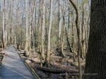
When I planned our route and where we would stop on our way to the Everglades and Key West back in 2008, I picked some places on the map I had never been to, including Congaree National Park.  When I googled it, I discovered that it had, until recently, been called Congaree National Swamp.  I guess I can understand why someone might think Congaree National Park was a better name.  After all, how many people think pleasant thoughts when they think of a swamp?

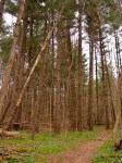
It only made me more curious to see it, however.  As we started down the very fancy boardwalk that kept less enthusiastic hikers’ feet dry, we spotted several woodpeckers and a couple of warblers in about 5 minutes.

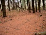
We continued well beyond the boardwalk and onto the trails for those with waterproof boots.  As we walked, a Barred Owl called over and over, completely oblivious to the fact it was 2 o’clock in the afternoon.  We heard a Pileated Woodpecker and saw it fly.  We followed it as long as the trail allowed, but I never did get a shot of it.  Of course, still toting my Powershot G3 that trip, I’m not sure how much of a shot I would have gotten anyway.

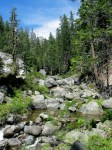
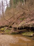
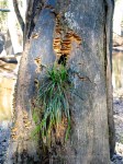
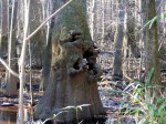
We continued along to a beautiful stream with giant swamp trees growing along the banks.  I assume they were Cyprus–the number of knees that threatened impalement to anyone who dared to trip was overwhelming.  I expected to see a few knees popping up here and there–the fact that acres of swamp were nothing but knees was quite a surprise to me.

But the biggest surprise was when we heard some rustling in the underbrush as we approached a darkly shadowed part of the woods.  We paused and looked at each other, unsure of what we were hearing.  Then, suddenly, several boar jumped up from their cover and went squealing off through the woods.

While I generally seem to lack the appropriate level of fear of wild animals, I have to admit that I definitely jumped when those pigs ran off through the woods.  Although I was disappointed I didn’t get a picture, I preferred missing the shot over having them run towards me.

At the time, I didn’t know that wild board were supposedly introduced here in the 16th century for hunting.  Who knew that the boar would go nuts and start taking over?  The amount of damage they can do is pretty frightening.  I don’t mean just to humans (although that’s frightening too) but to land, farms, and ecosystems in general.

I was a lot less excited about our wild boar encounter when I learned just how common they had become in the region and what a problem they are.  Much more recently, I discovered there’s a reality TV show about boar hunters.  Like most of the reality TV shows I’ve heard about, that just seems wrong.

In spite of the boar, I highly recommend hiking in the Congaree.

Almost Shenandoah

In 2008, I took my trusty PowerShot G3 for it’s final trip.  While I would have preferred my Canon 40D by then, since our plan included canoeing/camping in the Everglades, I was content to take a camera I wasn’t worried about ruining.

On our way to the Everglades and Key West, we stopped in Shenandoah.  It was on a list of places to see before you die, so we thought we’d check it out.  On our way through Virginia, we entered the North end of the park and managed to get in a short hike in thick fog before heading on toward lower elevations.  The fog was forming hoarfrost on the trees as we exited the trail.  We crept along the main road through the park, barely able to see a young buck walking along the road.

We made it safely to our hotel, where it was completely clear and much warmer.  The next morning, we learned the entire park was closed due to ice, but we were told to call back in a few hours–things might improve.

We decided to go for a cave tour nearby to kill the morning.  Luray Caverns was interesting. Although, because it’s privately owned, it’s treated commercially instead of for preservation purposes.  This means there were formations we could touch, lots of colored lights, a wishing well, and an organ that played a song by triggering mallets that hit various formations.  The cave was pretty astounding none-the-less.  I just hope it survives being shown off long enough for many to enjoy.

Returning to daylight, the valley was sunny and relatively warm for late December.  We decided we needed to get on the road whether we were able to hike in Shenandoah or not, so we drove on up to the park.

As we continued upward in elevation, the skies got cloudier and more and more of the scenery was blanketed in white.  As it turned out, all of the trees and roads were still frozen in a coat of ice.  It was beautiful to see, but the entrance to the park was closed.

Instead of hanging out for an extra day to see if things improved, we decided to take the Blue Ridge Parkway South and enjoy the scenery as we drove.

This turned out to be a surprisingly good decision considering the weather.  The further South we went, the sunnier the skies and we encountered no ice at all.  I guess the Parkway South of the park is a little lower in elevation.

We not only got to enjoy beautiful views of the valley below, but we were treated to spotting a couple of mountain goats tussling at the side of the road.  They were so entangled with one another, they looked like a two-headed goat.

We were sorry to leave the parkway behind, but we did make it to Congaree National Park early enough to take a long hike there and work the kinks out.

The Trail Less Traveled

The last installment (for now) from our backpacking trip to Yosemite . . .

Waking up that morning, we were the kind of tired you get from hiking a 1500 foot rise in elevation twice carrying close to 40 pounds on your back combined with not sleeping well.  One of my bad decisions to reduce the weight of my pack was to use an ultra-thin thermal sleeping pad that was 3/4 long.  That was a decision I would regret every night of our trip.  If there’s one thing a body needs when you’re pushing it hard is good rest and an ultralight, 3/4 length sleeping pad is not the way to get it.

So, there we were, still with no appetite although the nausea had subsided some, super tired, and in the middle of a mosquito festival.  We moved extraordinarily quickly getting out of camp that morning.  That’s one thing about through hiking–if you hate where you camp the first night, it’s only one night.

We were headed up the final ascent to El Capitan.  Although our tired bodies could feel the climb, it was a relatively gradual ascent.  Given we were already suffering from some altitude sickness, going up was not the best direction, but it wasn’t like we were climbing Everest and potentially going to die from altitude sickness.  We did not, however, move very quickly as we made our way up those last couple of miles to the top of El Capitan.

Fortunately for us, we weren’t far from the top.  We made it before lunch even at our snail’s pace.  Even more fortunately, our appetites started to return and we managed to snack and feel a little more energized before we got there.

As we walked out onto the top of El Capitan, any aches or pains were forgotten.  It was the first time we stood together looking at the panoramic view of Yosemite valley.  It was Pat’s first time in Yosemite, and I was relieved that he felt the same amazement I felt when I saw a similar view from the top of Half Dome a couple years earlier.

After the nausea, fatigue, poor night’s sleep, and mosquitos, I felt giddy with relief that Pat thought it was worth it to stand there with me.

We spent an hour there.  We had our lunch on top of El Capitan, enjoying the view and the sense of achievement.  While we didn’t climb up the face like the rock climbers who come every year, we had pushed ourselves enough to still feel that rush of “I really did something.”

Although we were there during peak tourist season, we didn’t see anyone until after we got past El Capitan.  Up until that point, we’d had the trail completely to ourselves.  Of the tens of thousands of people in the park at the same time we were there, not one of them crossed paths with us for that day and a half. We truly felt like wilderness explorers.

P.S.  In case you’re wondering, the photo with the “Outdoor Source” bandanna is because they offered a discount if you brought them a picture with their logo on the trail.

The Long Hike

Continuing from my last post, I’ll skip the other backpacking practice trips we went on between Wildcat Hollow and Yosemite–let’s just say that I experimented with “ultra-light backpacking” methods and decided having rain covers for the backpacks, a dry change of clothes, and a waterproof tarp was really worth the extra weight.

That said, we arrived in Yosemite fully prepared.  However, having spent the day flying across the country and driving to the park, we weren’t up for hitting the trail as soon as we got there.  Instead, we stayed in the Tent Cabins where we got to watch a video of a black bear peeling open a car door to get to a forgotten cookie.

We were very careful about using approved bear containers.

Our first day on the trail was a bit more complicated than we thought.  First of all, by the time we ate breakfast, got our gear packed, got our backcountry permit and bear canisters, and figured out where to safely store stuff we weren’t taking with us, it was nearly noon.

We also had a complication to deal with.  The trail we were going to take was closed.  We were going to have to take a different, longer route with more elevation ups and downs.  We hitchhiked for the first time (this is really not like hitchhiking on the freeway–even the park rangers suggested hitching to the trailhead).

It seemed quite a coincidence that a German picked us up given that my husband is German.  They chatted in their native tongue until our driver almost ran into oncoming traffic.  Then my husband decided maybe it wasn’t such a good idea to talk while the guy was driving.

We made it safely to our trailhead.  We started the long climb from the valley floor toward or goal, the top of El Capitan.  There are only two ways to get to the top of El Capitan:  hike the slow climb up the back or climb the steep face with ropes.  We picked the long, slow route.

The start of the trail was through what seemed like miles through a burned out area of the forest.  With no shade, we felt like we were being cooked like ants under a magnifying glass.  We were both relieved when we made it into the woods.

From then on, the scenery improved, water sources were plentiful, and Pat stopped complaining.  However, we both started suffering from mild altitude sickness.  Not something we expected at those elevation.

We ended up stopping short of our distance goal for the night.  We had trouble forcing ourselves to eat, feeling slightly nauseous.  We happened to pick a mosquito resort area, so we quickly retreated to our tent and went to bed early.  I realized as I fell asleep that the one thing I’d forgotten was gatorade–it’s awesome when altitude sickness is an issue and you need calories that don’t make you nauseous.

Oh, and the non-toxic mosquito repellant didn’t work.

Practice Hike

Back in 2004 (yes, more stories from my PowerShot G3 era), I talked my not-yet-husband into going backpacking in Yosemite.  He had never been backpacking before and he had never been to Yosemite before, so he was both excited about the prospect and nervous that I, the slightly more experienced backpacker, would mislead him in his preparations.

Since I hadn’t been backpacking for many years, I did the only logical thing.  I bought a stack of books about backpacking.  Then, I began equipping both of us.  The next logical step was to test it all out.

I also got to test my setup for taking pictures.  Instead of a strap, I used an elastic harness that took all the weight of my camera off of my neck, which was such a relief.  It also left my hands completely free.

Well equipped, we headed to Wildcat Hollow in Wayne National Forest.  It was the only place I found within a 2 hour drive that allowed backwoods camping.  The entire trail was about 12 miles–just long enough for a day and a half trip for us.

Although the hike started through a grove of evergreens, most of the trail went through deciduous forest.  In early April, just the beginning of spring growth was starting on the ground–the trees showed no signs of life at all.

As we made our way through the woods, we came to a stream with a beaver lodge.  Something was laying on top of the lodge.  We approached quietly, thinking we were going to get to see a beaver.  But, as we crept forward, I found myself wondering what a beaver would be doing on top of its lodge and how on earth it would get there.  I frantically tried to remember everything I knew about beavers.  I was pretty certain their lodges were supposed to only be accessible from underwater.

I guess when people say “only accessible from underwater,” they aren’t thinking about geese.  That’s what was stretched over the dome of the lodge–a large canada goose.  We watched for a long time trying to decide if it was alive, dead, or dying.  We saw it breathing, but decided it must be dying because it had its head down.  Coming up with no way to help this goose, we hiked on and tried to come up with alternative, more cheerful explanations.

When at last we found the perfect site to camp, we discovered how easy our new tent was to put up–it took 5 minutes.  We heated up instant soup on our tiny burner and hunkered over our hot soup cups as the temperature dropped.

We put on warm, dry long underwear and our warm wool hats before snuggling into our sleeping bags.  We slept pretty well, staying warm and dry all night.  When we woke up, it was snowing.

We hiked out with our bellies full of oatmeal and hot coffee feeling like we were quite the survivors.

Olympic Adventure

Whenever I go through old photos, I look for things I’ve learned as a photographer.  Sometimes it’s a little depressing.  It’s hard to say what improvements have come from skill vs luck vs improvement in technology.

However, I found one obvious improvement that can only be attributed to me having learned something–straight horizon lines.

Well, it’s not actually true that only my skill has straightened my horizon lines.  In truth, it wasn’t until I recently upgraded cameras and started using the in-camera electronic level that I can truly claim I had straight horizon lines.  But, setting that aside for a moment, as I look through images taken on my first trip to the Olympic Peninsula, shortly after I’d purchased my trusty old Powershot G3 circa 2003, I realize I didn’t even think about straight horizon lines back then.

So, there you have it. Solid evidence that I have retained one piece of information about how to have better images in 9 years.  I feel much better now.

The trek to the Olympic Peninsula from just North of Seattle seemed somewhat epic.  When you look on a map, Olympic National Park looks like it’s right next to Seattle–like it should take a couple of hours to drive there.  But the first hint that maybe it’s not so straight forward is when you try to get driving directions from Seattle to Olympic National Park–google says, “We could not calculate directions . . .”

Our route may not have been the most direct.  We went North through Deception Pass to Whidbey Island and, from somewhere in the general vicinity, we took a ferry over to Port Angeles on the Northern end of the Olympic Peninsula.  From there, we made our way along the coast down into the park where we visited an ancient lodge and trekked through an even more ancient rain forest.

Oh wait . . . that’s how we got there on our second trip to Olympic National Park.  Sorry.  On our first trip, we went South to Mount St. Helen first and then North to Olympic and then back via Port Angeles and Whidbey Island.  I had things reversed.

If Olympic were in the Northeastern United States and you asked someone for directions, they would tell you, “You cahn’t get theyah from heeah.”

I would love to go back to Olympic for a week.  Both times we went before, we did more of a drive by, taking only a couple of very short hikes.  I would love to do a through hike of many miles in the rain forest.  The number of elk that we saw in just a mile or so of walking in the midst of the deep shadows of giant trees was amazing–it wasn’t the kind of terrain I expected to find elk in.

It’s too bad it’s so difficult to get to–otherwise we would probably go every year as a short side trip from Portland when we’re out visiting my dad.

Maybe next year.

Venus Spotting

The Transit of Venus is one of those phenomena you have to get excited about, even though there’s a little voice that says, “it’s a black dot on the sun.”  You must ignore that little voice and get caught in the frenzy surrounding an astronomical event that won’t happen again for 105 years.

For me, the frenzy began when I read an article about it this morning, thanks to a post from a friend who is far better informed than I am.  I thought about trying to find a station on TV that was showing it instead of trying to see it.

Then, the frenzy ended about 10 minutes later when I promptly forgot all about.

After a long day of work, I decided to share Signal Point with my husband as a nice way to relax.  I promised him we wouldn’t hike any further than the 100 yards to the overlook from the parking lot.

I, of course, then packed up my camera, a couple of lenses, and my tripod.  Tisen packed as well.  As soon as he heard the first zipper, he started jamming toys into his mouth.  He managed to get both Tiger and Baby Beaver into his mouth at the same time.

When we arrived at the overlook, a man was already there with a pair of binoculars on a tripod and a camera sitting on the wall.  I was puzzled by his binocular setup–they were positioned about 3 feet above the ground and I couldn’t imagine how he could look through them at that height.  I asked him if he was seeing anything good, assuming he was looking for birds (what else are binoculars for?).

This is when I was reminded of the once-in-a-lifetime (well, twice) event I’d read about only a few hours before.  He used the binoculars to project an image of the sun onto a white card.  That way, we could safely view Venus passing in front of the sun.  Honestly, I was more excited to learn you could view the sun that way than by the black dot in front of the sun.  But it was pretty cool to be able to say we saw it.

I put a neutral density filter that blocks 10 stops of light (that’s a lot of light) and tried to shoot the sun.  However, I was worried about pointing my camera at the sun and, for whatever illogical reason, didn’t want to do so with my 70-200mm lens on it.  I’ve never heard of pointing the sun doing damage to a lens, just the sensor (and the photographer’s eyes), so I don’t know why I was worried about the lens, but shooting with a wide angle zoom only got me to 35mm–not exactly the best focal length for capturing  black dot on the sun.

I did get some interesting sunset shots and, even if we can’t see it, we know Venus is in there somewhere.

Fearless and Foolish

When I returned to Yosemite with my husband in 2004, after spending a night up on Clouds Rest, we hiked over to Sunrise Lakes and spent a night there.

Sunrise Lakes consists of three lakes that are at different elevations on the mountain.  We hiked our way up to the top lake, eventually coming to an area that was a popular place to camp.  As we passed a group’s campsite, a young woman stepped out of a tent.  She told us her friends went on a day hike and she decided to stay behind and read.  After chatting for a bit, we continued on, hiking over a ridge and finding a spot to set up our own, much smaller camp.

After getting our site setup, we were about to take a dip in the lake when the girl from next door appeared.

“Uh. . . can I hang out with you guys for a little bit?” she asked.

As it turned out, there was a black bear in her campsite.  I insisted we go back and chase it away or it would never leave them alone.

So, we returned to her site to discover a relatively small black bear (who was actually brown) had found a bag of trash that had been left in an open bear canister.

I have to take a moment to get on a soap box here.  We had never backpacked in a park where you had to use bear canisters before.  But, when we got our permit, the ranger explained to us why we needed them and how to use them.  We followed the instructions carefully.  They were simple:

  1. Anything that has a scent must go into the bear canister.
  2. Your kitchen area must be at least 50 feet from your tent
  3. Any and all leftover food, pot scrapings, wrappers, trash, etc have scent; refer to rule 1.
  4. The bear canister must be properly closed.
  5. A properly closed bear canister can be set on the ground in the kitchen area.

Although we found evidence the next morning that a bear had come through our campsite, as the rangers promised, when it discovered all the goodies were unobtainable in our canisters, it quietly moved along without even knocking over a canister.

But, back at our neighbors’ campsite, I should have been afraid of a roughly 400 pound bear with scary claws, but, he just seemed like a bigger version of our dog.  I experienced no fear.  I led the three of us as we shouted, clapped, and threw rocks.  Between throwing and clapping, I took as many photos as I could.  I can’t say I spent a lot of time on composition.

We chased the bear away, but, unfortunately, our neighbors didn’t learn their lesson.  A13 year old in the group left a container of Gatorade in her backpack and the bear harassed them all night long.

It makes me sad to think that bear may have eventually paid the ultimate price because people couldn’t follow simple instructions.

Climbing Up the Walls

Having made space in my photo library, I, of course, had to fill it.  I did this by importing an old archive of photos into my favorite photo management tool, Aperture.

An interesting thing happens when you import an old archive:  you watch your life flash before your eyes in the most literal of ways.

As I sat there going through time, I was reminded of many amazing things I’ve experienced in my life.  Of course, I find a starling with white tail feathers (which still eludes my camera) amazing, so I guess I’m easy to amaze.  I consider that a virtue.

Among these memories are a few moments when I was scared and not sure I could do something, but I did it anyway.  I’m sharing one of those today.

I had traveled to Yosemite with some friends I’d been training with for my first triathlon.  We went to San Francisco first where some of them (not me) did Escape from Alcatraz.  That was above my pain tolerance level.

In Yosemite, at the base of Half Dome, I stood looking up at the climb to the top of the dome and nearly didn’t attempt it.  If I am completely honest, it was only pride that motivated me to do the climb.

It’s hard to describe the climb.  I guess if you imagined people walking across a rope bridge and then imagine the bridge is vertical, hanging down the side of a mountain, and only has a floor-board every 10 feet, that would be close.

The boards are flat against the rock so you can perch and rest for as long as the people behind you will tolerate.  It’s probably not quite as vertical as it seems, but I felt like we were walking up a wall.

You are not tied to anything and you do not use any special gear.  Gloves are highly recommended, however.  If you arrive without a pair, there is a pile of gloves at the start of the climb left by those who completed it.  These are simple work gloves–nothing special.

I don’t know how long it took to complete this climb.  I just remember feeling grateful that someone slower than me was ahead of me–that gave me the time I needed to recover between resting perches.

When I made it to the top, what breath I had left was completely taken away.  There is an interesting phenomena that the harder I have to work for a view, the more amazing it is.  Part of the amazement is the sense of incredibly great fortune that I, a mere mortal of lower-than-average athleticism, am among the few to see it.

When Pat and I went to Yosemite together a couple years later, I tried to talk him into doing the climb.  That was a non-starter.  We hiked to several other views that were probably just as mind blowing, but they didn’t come with quite the same sense of elation.

*Photograph Credits:  these are not mine (in fact, I’m in 2 of them).  I’m not sure which friends took them, but I’m happy to have them.  Especially since I haven’t found my own photos from this trip–they may be in print only.

Above Infinity

Now that the heat has returned to Chattanooga, it seems like the perfect time to re-live part of our trip to Glacier National Park a couple years ago, where it was cool enough that it even snowed.

We started in Portland, visiting my dad, jumped on a train to Seattle where we met some friends.  Then, we went on across the continent (or so it seemed) overnight until we arrived at the tiny West Glacier train station.

Deposited at the depot so early in the morning that it wasn’t open yet, we stood on the asphalt area that served as a platform. surrounded by our rolling luggage.  We looked around in wonder.

By the time we discovered our rental car hadn’t been dropped off for us, got picked up by the rental company, and were outfitted with a four-wheel drive vehicle that was twice as big as anything I’d ever driven, we’d seen enough to be reminded why we love the Rockies.

But these Rockies seemed . . . rockier.  More rugged, bigger, bolder somehow than the Rockies of Colorado or Alberta.  But then again, I think I feel that way every time I return to the Rockies, no matter which part.

Our friends were only staying a couple of nights and then they were heading back without us.  Since they weren’t hikers, we took advantage of having a couple of non-hiking days to adjust to the altitude by doing things like driving to overlooks and walking on gentle paths around lakes.  There was an amazing amount of beauty to take in without pulling any muscles.

When we drove past a helicopter tour place, we girls were determined to get the guys on the copter.  I have often skipped helicopter tours opting to spend my money on a nice dinner with a decent bottle of wine instead.   But I always regretted skipping the helicopter tour in Hawaii Volcanoes National Park.  This time, I wasn’t about to miss it.

I laugh as I remember how hesitant the guys were to join us.  I really think they wanted to save the money.  I don’t think either one regretted having spent it by the time we landed.

There is something so spectacular about mountains.  To see them from above, with clouds nestling below their peaks . . . I imagine scenes from Greek mythology of the gods having a meeting or perhaps playing chess.  If I were immortal, this is definitely where I would hang out.

I cannot logically explain the effect mountains have on me, but I think it’s a common experience.  That sense of awe, grandeur, amazement.  The sudden stillness that follows the feeling of inspiration.  Feeling part of something bigger than my imagination. Perhaps a sense of being part of something infinite–the world seems so endless from a mountain top.

I wish these few photos contained that feeling.  Unfortunately, these are very low resolution versions of the originals (which, I hope, are stored away in an archive somewhere).