Sunless in Seattle

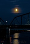
I love flying over Seattle.  There’s almost always clouds below the plane, blanketing the sky.  Then, suddenly, the peak of a mountain pops through like a giant whitehead.  Only an attractive one.  Mt Rainier particularly stands out.  Perhaps because it’s so rarely been visible from the ground on any of my trips to the area.

These photos are from the first time I went to Seattle, which wasn’t until 2004.  We went to visit some friends who had moved out there from Columbus.  We spent most of our time North of Seattle, but we decided to spend the last day of our trip downtown, exploring the city.

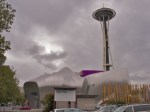
The Experience Music Project and Space Needle were two of the sites on our “must see” list.  Since they were co-located, it was pretty easy to work them both into our schedule.  As luck would have it, we had beautiful blue skies and sunshine that entire trip until the day we went into downtown Seattle.  I don’t know if this is because there is some sort of vortex over Seattle and causes it to be cloudy and rainy there all the time or if the maximum number of sunny days had been reached and the clouds were turned back on.

As we approached the EMP Museum, it looked mostly like a sheen of gray against a gray sky, drenched in gray mist.  We were happy to go inside.

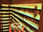
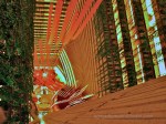
Seeing the collections of guitars was pretty exciting to my husband.  A little less so to me.  But, the tornado of guitars was pretty impressive.  In truth, there could have been absolutely nothing inside that building and I could have spent the entire day trying to figure out how to shoot its strange curves and intersecting angles.  Armed only with my PowerShot G3 at the time, I struggled with the lighting conditions for starters.  But more than that, trying to find a logical edge to decide on what to include and exclude from the frame seemed impossible as each shape flowed into the next.  Each attempt at framing a shot seemed like I was cutting off the flow.  Most of my shots are not even interesting enough to include with this post.

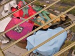
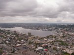
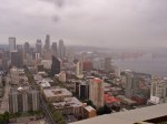
After exploring the interactive exhibits in the EMP, we made our way over to the Space Needle.  In spite of he rain, the view was pretty impressive.  We looked straight down on the EMP and got to look at the shape of tis exterior.  We also got a clearer view of how colorful the exterior really is.

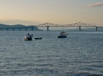
The Space Needle also afforded some great looks at the ports below.  Down in the park below, a group of kids were playing with giant water canons permanently mounted there.  I found it amusing that they were squirting each other with water while it was raining.

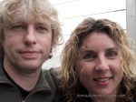
By the time we’d stood out on the observation deck for 10 minutes, we were both looking like drowned rats.

White Plains

Back a few years, which now seems like a lifetime ago, I used to go to White Plains, New York for work on a fairly regular basis.  There are several things I recall about White Plains, NY.  First, if you ever have to go there and someone suggests you should fly into LaGuardia or Newark, just say no.

The first time I went there, I flew into Newark on a Sunday and spent 3 hours trying to get across one bridge–there are really only 2 bridges to choose from when coming from Newark to White Plains and apparently the entire world is divided between those two bridges on a Sunday afternoon.

My second trip, I flew into LaGuardia and my transit time was cut to about an hour and a half.  On my third trip, when I arrived in Cleveland and ran for my connection, arriving at the gate all flushed and flustered just after the door closed, the gate agent asked me where I was going.  Not thinking, I replied, “White Plains.”  She looked at me and said, “The flight to White Plains is at that gate,” pointing at a gate across the aisle.  I managed to switch flights in time to go to White Plains.  When I arrived, I discovered that airport was exactly 8 minutes from the customer site I was visiting.

I asked the customer why they had recommended Newark or LaGuardia.  They’d assumed I wanted a direct flight.  They didn’t realize that I had to connect pretty much anywhere I flew to.  Still, I haven’t figured out why someone would think it was better to have a direct flight and a 3 hour drive (or even an hour and a half drive) than to have a connection and an 8 minute drive.  Even if I had an hour and a half layover, it’s more productive than an hour and a half sitting in traffic.

White Plains itself is quite beautiful.  Like most of the parts of New York I’ve been to (other than New York City), you see more trees than buildings.  Everything is cloaked behind stands of evergreens.  It’s hard to even tell when you’ve arrived at an office park.

For the less nature-centric, there is also good shopping, good food, great access to planes, trains, and any other imageable form of transportation (including horses, although I think they were all privately owned).  Just don’t try to drive there.

I had the rare pleasure of spending an evening alone with my camera on one of my trips to White Plains.  I made an exploratory pass around the neighborhood and found a lovely Spanish restaurant on the shore of the Hudson along with a park.  After filling my belly, I walked along the dock, taking pictures of the scenes on the river.

What was most surprising to me was the view of New York City.  Looking down the Hudson, Manhattan spread itself across the river like a bridge in the distance.

The Marriott Marquis

I was recently at a Photographic Society of Chattanooga meeting when the speaker displayed an image so familiar to me, I almost thought is was one of mine.  But, then I realized it was better than my version.

I don’t feel bad about this–the subject was the Marriott Marquis hotel in downtown Atlanta.  It may be one of the more striking architectural features in Atlanta (from the inside), but it’s also quite a challenge to shoot.  Plus, the day I got to shoot inside the Marriott Marquis, I had owned my PowerShot G3 for about 2 weeks and knew about as much about photography as my elderly aunt (who couldn’t figure out how to use a camera with only one button).

I was in Atlanta for work at the time.  There was a huge tradeshow there and I was playing “booth babe.”  This is a joke because I worked in the telecom industry at the time and it was considered bad form to have anyone in any booth looking anything other than geeky.  I got to don a men’s button-down shirt that would have fit great if I were shaped like a large block and was long-waisted and short-legged.

But, I digress.

Just by good fortune, I was staying at the Marriott Marquis.  I had no idea at the time that it was going to be a photographic opportunity.  I brought my brand new, fancy point-and-shoot camera purely because I was so excited about having what was then by far the nicest camera (digital or film) I’d ever owned that I brought it along purely out of the desire to learn how to use it.

The problem with the Marquis is the difficulty of getting what you want in the frame without getting what you don’t want.  For example, you cannot get the entire stunning view of the balconies into the frame.  My focal length was 7mm for these shots.  I don’t know of an SLR lens that will go that wide unless it’s a fisheye.  Additionally, it’s a hotel with lots of people milling about doing what they want without concern for your shot–they’re there day and night.  A long exposure on a tripod might have done the trick for removing some people, but there are always people standing on the balconies gazing down and up and taking in the incredible structure.

Another problem is the lighting.  Higher up, the balconies get quite dark.  It’s difficult to get a balanced exposure that shows both the lower and upper balconies.

As someone who was:  there for business, without a tripod, in a hurry, and using a point-and-shoot I barely knew how to use, I think I walked away with some surprisingly good shots.  Of course, I cannot look at them now without thinking about how much better I could do today.  Atlanta is only a 2 hour drive–maybe I’ll have to actually go test myself one of these days.

Moon Meetings

Rushing to catch the full moonrise, I turned the corner onto Market St and got my first view of the horizon, a thin line of orange glowing just over the tree tops.  I started running again.  By the time I got far enough across the bridge to have good angle, the orange glow had disappeared.

I got my camera set on the tripod, got focused on the bridge, and waiting.  Then I waited more. About the time I got tired of waiting and decided to swing the camera around to shoot the sunset until the moon appeared, I saw a movement out of the corner of my eye and about jumped into traffic with surprise.  A man apologized for scaring me and then said something about my camera.  I smiled and he smiled back and then he walked away.  I have no idea what he said, but apparently a smile was an appropriate response.

Moments later, another man showed up.  This one with a camera in hand asking me if I knew where the moon would rise tonight.  I told him about the orange glow I’d seen.  He told me that he was the architect for the current, restored version of the Walnut St bridge and he’d been wanting a picture of the full moon rising over the bridge for years.

We waited together for the moon to reappear.  Eventually, I spotted another band of orange glowing through the heavy clouds.  We both started shooting like mad.

He wanted a very specific image with the moon centered over a pier of the bridge (or whatever it’s called).  I was hoping more for images with people in front of the moon.  Unfortunately for me, the moon was too high by the time it appeared from behind the clouds for anyone to be in front of it.  I lined up behind my new acquaintance and shot over his head as he bent over the rail of the Market St bridge in front of me.

Eventually, the architect’s wife pulled up in a car, pulling over in heavy traffic just long enough for him to jump in.  I was left to continue shooting on my own.  I shot as wide as my lens and teleconverter would allow, fascinated by the reflection of the moonlight on the water.

Then, another car pulled over.  A third man asked if I could send him some photos–he and his wife were trying to take pictures of the moon with a cell phone.  I asked if he had a card and his wife, apparently hidden in the back seat, leaned forward with a car from a vineyard in Ringgold, GA.  The man said, “Send us a picture and we’ll send you a bottle or wine!”  I wondered how good my picture had to be for a bottle of wine.

It’s funny how people seem to assume you’re going to get a great image when you’re shooting with a long lens.

Dogs and Tents

We have decided to take two days to go backpacking.  It’s been a long time since we spent the night in backcountry.  We have chosen a pretty easy place to re-introduce ourselves and expose Tisen for the first time.  At least, we think it will be easy.  What’s 7 miles with 35 pounds on your back?

We have a checklist of things to pack for our dog:

  • Medications (the only one with no insurance is the only one on medication!)
  • Vitamins
  • Special food (because he has allergies, which led to the medication in the first place)
  • Insulated and padded sleeping roll for dogs
  • Collapsible water bowl
  • Water bottle
  • Wipes to remove poison ivy from his fur (for my protection, not his)
  • Super glue (in case he cuts a paw pad)

Given the list, it seemed logical to me that Tisen would carry some of his own stuff.  At least his own food and first aid items.  So, I had him fitted for his own backpack.  Pat vetoed the backpack idea.  He thinks Tisen will be sore from walking so much and doesn’t need to carry any extra weight.  He has a point.

Of course, once we agreed no backpack for Tisen, it was like he knew he wasn’t going to be carrying anything so he started adding to the pile of gear.  First Blue Dog appeared on the pile.  When I moved Blue Dog, Lion showed up.  Most recently, it was Duck.  I haven’t broken it to him that he’s not going to be able to bring any of them on the trail with him.

We have, however, had pre-camping lessons in the living room.  We wanted to see if Tisen would fit in the tent with us.  It’s going to be a tight fit, but if he lays parallel to us, we can put his sleeping mat under our mats (which are narrow at the feet) and he can lay between our sleeping bags.  As long as no one moves, it should be super comfortable.

We also practiced entering and exiting the tent.  We wanted to make sure Tisen would get in and out quickly so we don’t end up with a swarm of mosquitos cuddling up with us.  After a couple of practices, he was coming in and out like a trooper.

Next, I practiced getting up to heed the call of nature (which happens about 8x a night when I am camping just because it’s so inconvenient, I think) and leaving Tisen in the tent.  He did pretty well lying still while I got out and back in again.

I think we’re ready.  Now we just have to figure out how to stuff it all into our backpacks.

On a photography note, what’s really amazing about the shots in the gallery is that all but the first one were shot at 25,600 ISO.  The darker images have some grain, but they look better than the Canon 40D did at 800 ISO.  That’s pretty impressive.

The Last Push

After spending some time cooling in a stream, Tisen and I make the final push home from Edward Point.  We make it to the first place we got lost on the way out.  When we get there, it’s completely obvious that a lower trail completely avoids the downed trees that caused us so much trouble on the way out.  We make it around the whole area with only one lift for Tisen in a spurt of steep rock steps.  I cannot resist looking to see if the trail was obvious from the other side.  It was not.  I have an excuse for at least one of my wrong turns.

I’m almost afraid to stop again.  Tisen is moving well and looking energetic.  I’m moving well now that we’re going uphill, my knee only complaining when we go downhill.

We make it back to the first natural overlook and I know we’re home free.  We take a break there, just to be safe.  Tisen looks at me with an expression on his face that I swear says, “Yay, Mom!  Look at us!  We’re almost back!”  Who knew a bit bull could look like a cheerleader?

A couple pauses to take a few quick shots from the overlook while we gather our energy for the last push.  The trees start rustling, the sun disappears, rain drops start to fall.  I realize I have nothing to cover my camera with and hope that it doesn’t get too wet.

I text Pat and let him know that we have survived and are on our way home.  I had updated him earlier when we were lost–one of the advantages of hiking on Signal Mountain is that you still have a signal.  🙂

When I start packing up Tisen’s water, Tisen pops up like he’s been waiting on me all along.  I smile.  I don’t know if he remembers what the last part of the trail is like, but it involves a lot of jumping up onto high steps and rocks to get back to the manmade overlook at the parking lot.  It’s a lot to ask of a tired dog.  I prepare myself for the possibility of having to lift Tisen many times in the last quarter mile.

Tisen springs up every rock and step like a young pup.  He is clearly excited to be getting closer to home.  He charges ahead when I pause.  When he’s behind me, I have to be careful not to kick him as I step, he’s so close on my heels.

We make it to the park.  We make it up the final hill to the car.  Tisen catapults himself into the back seat and lies there panting.  I rush to change my shoes so I can get us moving.  The breeze is still blowing, cool and slightly damp, although the rain has stopped.  I smile to myself as I put the car in drive:  we finally made it to Edward Point.

Blazing Trails

After allowing Tisen a 20 minute nap at Edward Point, I decide we’d better start working our way down.  With our side-trips on the way up, we’re an hour behind schedule and we’ll be two if it takes as long to get back.

Unfortunately, the sun is now higher, the temperature hotter, and the bugs swarming more energetically.  I’m not sure if it’s the heat or the bugs that get to Tisen, but not more than a 1/4 mile from Edward Point, he finds a shrub, runs into the shade underneath, and starts digging himself a nest in the dirt.  It takes quite a bit of coaxing to get Tisen back out into the sun.

Fortunately, we are back in the shade a little further down the trail.  And the turkey vultures who greeted us on the way up have given up on us dying, disappearing down the river valley.  I took that as a positive sign.

Because I had opted to break in my new hiking boots in anticipation of a back-packing trip the following weekend, my knees were suffering.  My left knee was the first to start screaming.  This has something to do with inflammation.  As my knee starts to swell, it no longer wants to bend.  When I bend it and step downhill, a sharp stabbing pain shoots through the joint.  It makes going downhill excruciating.  I make a mental note to make sure I figure out how I can carry my camera and still use my trekking poles before we set out backpacking next weekend–I imagine my knees won’t hold up to a backpack without trekking poles.  I wish I could wear my fivefinger shoes, but the rocky terrain and the extra weight of a backpack is a bit much for almost-bare feet.

We manage to stay on the right trail on the way back.  I am watching for blazes with the intensity of a pit bull.  Or maybe that’s Tisen?  When we get to the juncture where I went the wrong way on the way up, I look back to see how I got confused.  I realize there is no excuse for missing the main trail.  The blazes are obvious and well-placed.  I don’t know what I was thinking.

We keep on stepping, slower than I’d like, but we’re making more progress than if either my knee or Tisen gives out completely.  I have to lift Tisen over some big rocks in the part of the trail we missed on the way up.  While I’m glad I’m able to lift him, I am simultaneously worried about how much poison ivy he’s run through and how much of it each lift is getting on me.

We make it back to water.  Tisen plows in and lays down.  I watch and wait for him to look cooled and refreshed so we can continue on our way.

Edward Point

As Tisen and I walked what we thought was the last 15 minutes to Edward Point, shadows raced across the forest floor like silent, dark ghosts.  I looked up to discover a half a dozen turkey vultures circling overhead.  Close overhead.  Too close.

Given we were hot, tired, and bleeding from numerous wounds from brambles, it was a little ominous to feel like they were so interested in us.

Fortunately, they soared further away as we approached, giving us a more breathing room.

As we looked around (well, I looked around, I don’t know what Tisen was doing exactly), I realized that the area must have had a fire in recent years.  The trees were charred in place.  The growth was thick and dense, but it was all wild flowers and sun-loving brush.  The bugs loved it.  I couldn’t seem to keep them off of me.  I saw bugs on me that I’d never seen before.  I stopped shooing and started swatting, leaving red hand-prints on my arms.  They went well with the bleeding scratches from the earlier brambles.

There is something disconcerting about hiking from relatively deep forest into bright meadows when a mountain is well below timberline.  You expect to come out into open spaces when hiking in Colorado, but here, it just seems wrong.  I found myself wondering when the forest had burned and whether that was normal here in the Eastern  US.

About 15 minutes after we’d found our way back to the Cumberland Trail, we encountered an overlook that faced the cliff on the other side of the gulch.  Directly across from us was a huge building that absolutely looked wrong.  There is nothing I resent more than when I spend hours making my way to a overlook in the “wilderness” only to discover I’m within a football field (or two) of a major development.  I found myself hoping this was not, in fact, Edward Point.

I googled Edward Point to see if I could tell.  Thankfully, I was able to determine that we were not there yet.  Now, I had a decision to face.  A 72-pound dog who is tired and hot and 45-year-old knees that are equally tired give one pause at moments like these.  Had it been me and only me, there would have been no hesitation–I was going to make it to Edward Point this time no matter what.  However, I’d lifted Tisen enough times on the way up to know I couldn’t carry him back.  I had to consider whether he could make it or not.

I decided to give it another 10 minutes.  I could see where we were along the gulf and it seemed like Edward Point, which overlooks the main river valley, had to be close.  I was so glad we’d stuck it out when we arrived at the overlook.  While Tisen took a nap in the shade, I took as many photos of the view as I could.

Lost Again

Tisen has a very specific way of cooling off in streams. He walks in, feels around with his feet until he finds the perfect spot, then he lays down.  I suspect it has something to do with his Holstein genes.

Having cooled off for several minutes and drunk his fill of water, Tisen recovered enough to tackle the uphill climb.

As we made our way of the far side of the gulch, the climb got steeper.  We were distracted by the amazing rock formations.  Perhaps this is why, when we got to the next junction in the trail, I decided we needed to head downhill rather than up.  This turned out to be a bad mistake.

We ended up on a trail that kept getting narrower and more overgrown.  Soon, we were walking through brambles that hooked themselves into bare skin, tearing flesh as I forced my way through.  Tisen was somewhat protected by his fur, but both of us looked like we’d taken a beating by the time we got to a clearer part of the trail.

The trail now tucked up against another rock bluff, looking more like a deer trail than a parks and recreation trail.  I should have turned around about a 1/4 mile in.  Have I mentioned I have issues with going backwards?

On the plus side, since nature was calling pretty loudly at this point, it was good that we were in an isolated area with plenty of underbrush so I could heed the call without fear of someone walking up on me.  On the minus side, there were so many enormous spider webs in the rocky bluff I was almost afraid to turn my back on them.

When we got around the bluff, we started bush-whacking uphill, hearing voices above us and thinking that must be the main trail.

This was tough going.

Not only were there more brambles and spider webs, but now there were more and more rocks to climb as well.  I was worried about Tisen getting a little more exercise than he could handle.

As we walked along the face of yet another rock bluff, we caught up with a couple with a child and two dogs.  I have no idea how they all got there, but there they were.  I asked them where we were and they assured me that we were just below the Cumberland Trail.  All we had to do was go straight up the rock face.

I found an entry point that I could climb, lifted all 72 pounds of Tisen up onto the rock at shoulder height and managed to convince him to stay up there while I used a tree to assist my own ascent.

Bush-whacking through another patch of brambles rewarded us with being back on the main trail.  The couple had said Edward Point was about 15 minutes away; had it been much further, I probably would have started heading home.

Beyond the Overlook

Continuing our hike from Signal Point to Edward Point, Tisen and I made our way along the steep slope of the gully.

I guess it’s a gully.  I’m not really clear on when a gully becomes a canyon or if there’s some other name for a horse-shoe-shaped space in the side of a mountain, but essentially, we were going to hike in nearly an ellipse, but we were going to end up on a point on the opposite cliff from where we started.

The trail starts high, goes mostly downhill to the midpoint and then climbs again to Edward Point overlook on the far side.  It requires stepping over, on, or around many rocks in the process.  We clambered our way up the trail, keeping a pretty good pace going.  I eyed the poison ivy growing along the trail with disdain–I knew it meant Tisen and I were going to be taking very thorough baths that night.

When we got about another 1/2 mile down the trail, we ran into an impasse.  This happens quite frequently on trails.  A tree has fallen across the trail that can’t be gone over, so you have to go around.  Usually, this might mean walking a 1/10 of a mile out of the way to skirt the fallen tree.  In this case, there were dozens of trees that had fallen.  It was a terrible scene of destruction that made me sad.  On the other hand, with as many bad storms as have rolled through this area in recent years, it’s pretty amazing that that’s all the damage that’s been done.

But there were piles of fallen trees.  And we we tried to go around, we ran into only more fallen trees.  We went around and went around some more, trying to find a route through all the crap that fell with the trees.  Eventually, we did make it.

Of course, in the process, I lost the trail.  We ended up bush-whacking our way back to the trail, arriving slightly scratched and a little more tired than we would have otherwise.

When we finally found the main trail again, we hadn’t gone more than 10 feet hen we saw a junction with a trail that came from the same direction we had just come from.  It was clearly blazed as the main trail and it looked like it would have missed all of the fallen trees.  I kicked myself and wondered how I had missed that option when we took the high trail to hell.

But, back to relatively clear sailing, we continued on our way, making it to the point where we’d turned around the first time we tried to hike this trail and pushing beyond.  Less than a 1/4 mile past our previous turn-around point, we ran into a stream.  Tisen made quick work of laying down in the water to cool off.  I thought about joining him, but there wasn’t a puddle big enough.