Tiger Key and the Manatee

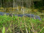
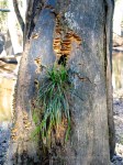
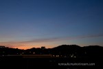
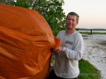
The tiny keys that dot the Gulf Coast of the Everglades are countless.  But the ones that are big enough to land a canoe on and pitch a tent have names.  They are supposedly named after the shape of the key when viewed from the air, but I suspect Tiger Key was actually named in honor of the ferocity of the insects there.

Fortunately for us, when we climbed cautiously out of our tent on Boxing Day, the wind had kicked up and we were spared the brutal attack of the night before.  It was an enormous relief not to do battle again first thing in the morning.

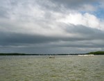
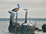
It was time to return to the mainland.  We were somewhat concerned that we would not be able to find our way back having gotten so lost on our way out.  Fortunately, we were traveling via major channels most of the day.  While this made navigation easier, it greatly reduced the wildlife we saw.

By the time we were in the main channel, we got into a rhythm like we’d been paddling a canoe every day of our lives.  We laughed at a couple heading out.  They were struggling to go downstream because they were paddling against each other–the wife was literally paddling backwards.  We felt like canoe paddling champions as we dug into the water and pulled our canoe against the current.

Then, we got to the final stretch.  We could see our destination.   It was a short distance compared to the many miles we’d paddled over the last three days.  But the current was so strong that it pushed us sideways across the channel.

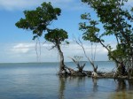
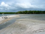
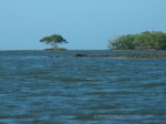
We spotted a small island along the way where we could land and catch our breath.  We made it to the closest end of the island.  After resting for a few minutes and saying a few choice words, we pushed off for what we thought would be our final launch.

We paddled for all we were worth, but the current pushed us back to the far end of the island we’d just left.  We’d have spent less energy walking the canoe along the shore.  Neither of us felt much like a champion paddler anymore.

We took a longer rest.  We ate a snack.  We got out of the canoe.  We stretched.  Then, we rallied and drove that canoe right across the current until we suddenly found ourselves in calm waters and could relax for the final 50 yards of our trip.

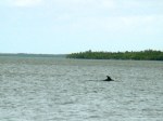
As we slowed down, a large, dark mass rose towards the surface of the water.  Pat yelled, “Manatee!”  We were so excited we nearly capsized the canoe after 3 days of remaining afloat.

As we glided closer to the slowly moving mass, we felt ourselves blush as we realized it was a mass of algae.  No manatees in sight.

Despite the disappointment, we really felt like we’d done something when we beached the canoe for the final time.  It was the best Christmas ever.

Jumping the Moat

Continued from Lost and Found.

Christmas morning we woke up early and laid there in the dark, realizing we could no longer hear the Gulf slapping the banks of our tiny island.  Even when we held our breath, we couldn’t hear the waves.

When at last dawn lightened the sky, we decided to get up and get an early start in our canoe.  We had about 8 miles of paddling in store for us and we were already sore from paddling yesterday.

When we stepped out of the tent, we discovered our tiny island had become a giant island at low tide.  Actually, it was still a tiny island, but now it was surrounded by a giant moat.  The Gulf was suddenly so far away, it was almost unbelievable last night we were worried our canoe would get washed away by high tide.

We ate breakfast slowly.  We walked around the island and watched the sunrise.  We packed up our campsite.  We loaded up the canoe.  All the while, the water was slowly rising, coming closer, but it still looked hopelessly far away.

Having nothing left to do, we sat and waited.  But then, the wind died and we were sitting ducks for biting insects.  We were suddenly motivated to find a way across the moat, dragon or not.

We slid our canoe along the murky shore while we walked as far as we could on dry land.  We found that the opposite end of the island was closer to deep water than our end, so we edged our way through thick mangroves until we finally stepped into the muck and pushed our canoe and gear through the shallows until there was enough water that we could get in and paddle away.  We were itchy with drying muck as we paddled off into the sun.

We hadn’t been out too long when we saw a strange line of evenly spaced white dots stretched across the horizon.  As the dots got larger, we realized it was a large group of American White Pelicans flying in precise formation, sweeping the surface in search of prey.  They flew to a shoal where a huge conglomeration of pelicans gathered.  That might have been the best Christmas present ever.

When we stopped for lunch somewhere between Rabbit Key and Tiger Key, we discovered a family of Osprey.  The young were nearly the size of their parents and angrily demanded to be fed while their parents seemed to argue that it was time for them to leave their nest.

We arrived at Tiger Key without any navigational hiccups.  But the wind soon died and we discovered “no-see-ums.”  I tried a trick someone told us–smearing baby oil on my exposed skin.  I ended up looking like human fly paper and they still bit me–my skin looked like a basketball.

Thankfully, we managed to keep the bugs out of the tent and fell asleep with smiles on our faces, dreaming of Osprey and Pelicans.

Lost and Found

The first day of our canoeing adventure along the Gulf Coast in the Everglades, I discovered a key difference between canoeing in the Everglades and canoeing down a river.  There’s only one way to get lost when you canoe downstream on a small river:  failure to stop at the pick up point.

Canoeing in the Everglades was a completely different story.  We had a permit to camp on a particular Key each night of our trip.  Our first day, we were supposed to paddle about 7 miles to Rabbit Key.  Unfortunately, we started out heading down the wrong channel through the mangroves.  As we paddled around trying to identify openings between tiny mangrove islands that matched shapes on our map, I realized how little a map drawn from an aerial perspective reflects what land looks like from the water.

As the navigator, I eventually gave up on the map all together, picked a channel that pointed generally Southwest, and took us through the maze of mangroves until we hit the Gulf.  Assuming we were West of our destination, we paddled East.

Paddling along the Gulf Coast through swells of salt water in a canoe identical to the canoes we’d paddled as children was a completely surreal experience in and of itself.  Then, we spotted a dolphin about 50 yards from our canoe.  It was a joyful sort of strange.

After having paddled long and hard in the Gulf (which is not at all like paddling down a river) we decided to break for food and try to locate ourselves on the map.  We figured we might just stay where we were.  We were rapidly running out of daylight and we really wanted to have our campsite setup before dark.

We took a walk around the island we’d stopped on, trying to get a sense of what it might look like on our map.  Fortunately, we stumbled across a sign that identified the Key we had landed on.  It was Rabbit Key, the key we were supposed to spend the night on.  While this was mostly pure luck, Pat was still impressed by my sense of direction (too bad it doesn’t seem to work in the Chattanooga area).

Taking some advice someone had given us, we found a suitable spot to pitch our tent where there was plenty of wind.  Then, we pulled our canoe well up out of the water so it wouldn’t float away at high tide.  We ate quickly and went to bed, exhausted.

In the middle of the night, I woke up and went out to heed the call of nature.  When I looked up at the night sky, I’d never felt so close to the stars.  I’ve been to the top of Maunakea, which is supposed to be one of the best places in the world to see the stars, but here at sea level on a tiny key in the Everglades, it seemed like the stars were within arms reach.  It was astonishing.

See Ya Later

Nearly a week into our 2008 Christmas road trip, we made it to Everglades City, Florida.  We were looking forward to 3 days of canoeing and camping along the Gulf Coast.  But, the day we arrived, we decided just to enjoy the surroundings and spend the night comfortably in a local bed and breakfast (who also happened to rent canoes).

Before we could really enjoy ourselves, we decided to head to the local grocery store and stock up on supplies for our camping trip.  This did not take long because the local grocery store was about the size of a large convenience store at a gas station.  There was very little selection and only one brand of anything they carried.  This had the advantage of making decisions very easy.  Do you want bottled water?  1 liter or 2 gallons?  Do you want beef jerky?  Oh, they’re buy 3 get one free.  Do you want granola bars?  1 box or 2?  I love easy decisions!

On the way back to the hotel, we discovered a roadside park with a lovely swamp occupied by so much wildlife, at first I thought it was a zoo.  I couldn’t get over the birds.  If all birds were that big, birding would be so much easier!

The Cormorants stood around drying their wings.  The Little Blue Heron posed while stalking fish.  And the Anhinga, well, they were the most amazing of all.  I saw a stick poking up through the surface of the water and suddenly realized it wasn’t a stick at all!  It was the beak of an Anhinga who was walking along the bottom of the pond with its beak sticking up through the surface like a breathing tube.  I don’t know if it was really breathing, but I was blown away by the scuba diving bird!

If the birds weren’t enough, the alligators added a whole new level of excitement.  While you can’t tell from the photos, there was a fence between the closest alligators and us.  Although, it was a fence they could have run around to get to us.  I’ve heard alligators are pretty fast, but Pat kept an eye on the gators to make sure none were sneaking up behind me when I was looking at his brother.  You have to respect any animal that has been around for as many millennium as the alligator.  They reek of ancientness.

Amazed, loaded with images, and stocked with food for our trip, we decided to try a local restaurant that was recommended to us by the bed and breakfast.  It was one of those hyper casual places that served on picnic tables with paper plates.  But I had the best salad I’ve ever had in my life there–the greens, herbs, and flowers (yes flowers) were all grown in the restaurant’s own garden.  Just writing about it makes me want to return just to have another one of those salads.

It was a great way to prepare for our canoeing adventure.

Swamp or Park?

When I planned our route and where we would stop on our way to the Everglades and Key West back in 2008, I picked some places on the map I had never been to, including Congaree National Park.  When I googled it, I discovered that it had, until recently, been called Congaree National Swamp.  I guess I can understand why someone might think Congaree National Park was a better name.  After all, how many people think pleasant thoughts when they think of a swamp?

It only made me more curious to see it, however.  As we started down the very fancy boardwalk that kept less enthusiastic hikers’ feet dry, we spotted several woodpeckers and a couple of warblers in about 5 minutes.

We continued well beyond the boardwalk and onto the trails for those with waterproof boots.  As we walked, a Barred Owl called over and over, completely oblivious to the fact it was 2 o’clock in the afternoon.  We heard a Pileated Woodpecker and saw it fly.  We followed it as long as the trail allowed, but I never did get a shot of it.  Of course, still toting my Powershot G3 that trip, I’m not sure how much of a shot I would have gotten anyway.

We continued along to a beautiful stream with giant swamp trees growing along the banks.  I assume they were Cyprus–the number of knees that threatened impalement to anyone who dared to trip was overwhelming.  I expected to see a few knees popping up here and there–the fact that acres of swamp were nothing but knees was quite a surprise to me.

But the biggest surprise was when we heard some rustling in the underbrush as we approached a darkly shadowed part of the woods.  We paused and looked at each other, unsure of what we were hearing.  Then, suddenly, several boar jumped up from their cover and went squealing off through the woods.

While I generally seem to lack the appropriate level of fear of wild animals, I have to admit that I definitely jumped when those pigs ran off through the woods.  Although I was disappointed I didn’t get a picture, I preferred missing the shot over having them run towards me.

At the time, I didn’t know that wild board were supposedly introduced here in the 16th century for hunting.  Who knew that the boar would go nuts and start taking over?  The amount of damage they can do is pretty frightening.  I don’t mean just to humans (although that’s frightening too) but to land, farms, and ecosystems in general.

I was a lot less excited about our wild boar encounter when I learned just how common they had become in the region and what a problem they are.  Much more recently, I discovered there’s a reality TV show about boar hunters.  Like most of the reality TV shows I’ve heard about, that just seems wrong.

In spite of the boar, I highly recommend hiking in the Congaree.

Almost Shenandoah

In 2008, I took my trusty PowerShot G3 for it’s final trip.  While I would have preferred my Canon 40D by then, since our plan included canoeing/camping in the Everglades, I was content to take a camera I wasn’t worried about ruining.

On our way to the Everglades and Key West, we stopped in Shenandoah.  It was on a list of places to see before you die, so we thought we’d check it out.  On our way through Virginia, we entered the North end of the park and managed to get in a short hike in thick fog before heading on toward lower elevations.  The fog was forming hoarfrost on the trees as we exited the trail.  We crept along the main road through the park, barely able to see a young buck walking along the road.

We made it safely to our hotel, where it was completely clear and much warmer.  The next morning, we learned the entire park was closed due to ice, but we were told to call back in a few hours–things might improve.

We decided to go for a cave tour nearby to kill the morning.  Luray Caverns was interesting. Although, because it’s privately owned, it’s treated commercially instead of for preservation purposes.  This means there were formations we could touch, lots of colored lights, a wishing well, and an organ that played a song by triggering mallets that hit various formations.  The cave was pretty astounding none-the-less.  I just hope it survives being shown off long enough for many to enjoy.

Returning to daylight, the valley was sunny and relatively warm for late December.  We decided we needed to get on the road whether we were able to hike in Shenandoah or not, so we drove on up to the park.

As we continued upward in elevation, the skies got cloudier and more and more of the scenery was blanketed in white.  As it turned out, all of the trees and roads were still frozen in a coat of ice.  It was beautiful to see, but the entrance to the park was closed.

Instead of hanging out for an extra day to see if things improved, we decided to take the Blue Ridge Parkway South and enjoy the scenery as we drove.

This turned out to be a surprisingly good decision considering the weather.  The further South we went, the sunnier the skies and we encountered no ice at all.  I guess the Parkway South of the park is a little lower in elevation.

We not only got to enjoy beautiful views of the valley below, but we were treated to spotting a couple of mountain goats tussling at the side of the road.  They were so entangled with one another, they looked like a two-headed goat.

We were sorry to leave the parkway behind, but we did make it to Congaree National Park early enough to take a long hike there and work the kinks out.

Riverbending

When we made the decision to move to Chattanooga, we knew about Head of the Hootch (a huge rowing event here in the fall) and we thought that was THE big event in Chattanooga.  However, it turns out Riverbend is THE big event here.

Just by chance, we completely missed Riverbend last year.  Our visit to pick a place to live was in March.  Our visit to make it official was in July.  Riverbend happens in June.

Riverbend, is a 9-day music festival that, this year, features 6 stages and something around 100 bands.  Supposedly, 600,000 people will descend upon Chattanooga (population 300,000) for this event.

The first sign that Riverbend was coming was the arrival of a stage via barge.  It was floated up the Tennessee River and parked for a couple of weeks in front of the Aquarium.  Eventually it was raised onto a huge dock (we always wondered why that dock was so big) where it had quietly remained for at least a week before the opening of the festival.

During that final week, tents started appearing followed by rides.  Soon, the riverfront looked like an abandoned carnival.  Billboards all over town advertised “get your pin at such and such place.”  Pins were $32 for entry all 9 days.  Of course, “entry” doesn’t include the lawn in front of the main stage (another $10), a program (yet $35 more), or seats anywhere.

Had we know pins at the gate would be $45, we would have bought our pins early.  We, of course, didn’t discover this until after the discounted pins were no longer available.

Finally, opening night came.  It was Friday night, June 8th.  We expected to hear the bands playing from our place, but they were drowned out by traffic noise on this side of the river.

Instead, the start of the festival was announced to us by a ridiculous amount of noise on the roof over our heads.  Some of our neighbors had apparently invited a large group of friends over to hang out on the roof deck; we’re pretty sure they spent the night.

I went up to the roof top to check out who was up there and to see what kind of shots I could get from the roof.  I left my 100-400mm lens at home since I figured I was going to need my faster 70-200mm lens in the twilight over the extra length.

Alas, the scene was far enough away that I couldn’t get very interesting shots of any details.  Plus, I couldn’t see the river from our roof, which was full of boats listening to the music.

I turned to the sunset briefly (reminding myself that I have too many shots of the sunset and it wasn’t that interesting) and then returned to shoot the skyline wide.  Sine the sky was completely uninteresting that direction, I cropped those shots to panoramic proportions.  I probably should have just put my camera away instead.

The Trail Less Traveled

The last installment (for now) from our backpacking trip to Yosemite . . .

Waking up that morning, we were the kind of tired you get from hiking a 1500 foot rise in elevation twice carrying close to 40 pounds on your back combined with not sleeping well.  One of my bad decisions to reduce the weight of my pack was to use an ultra-thin thermal sleeping pad that was 3/4 long.  That was a decision I would regret every night of our trip.  If there’s one thing a body needs when you’re pushing it hard is good rest and an ultralight, 3/4 length sleeping pad is not the way to get it.

So, there we were, still with no appetite although the nausea had subsided some, super tired, and in the middle of a mosquito festival.  We moved extraordinarily quickly getting out of camp that morning.  That’s one thing about through hiking–if you hate where you camp the first night, it’s only one night.

We were headed up the final ascent to El Capitan.  Although our tired bodies could feel the climb, it was a relatively gradual ascent.  Given we were already suffering from some altitude sickness, going up was not the best direction, but it wasn’t like we were climbing Everest and potentially going to die from altitude sickness.  We did not, however, move very quickly as we made our way up those last couple of miles to the top of El Capitan.

Fortunately for us, we weren’t far from the top.  We made it before lunch even at our snail’s pace.  Even more fortunately, our appetites started to return and we managed to snack and feel a little more energized before we got there.

As we walked out onto the top of El Capitan, any aches or pains were forgotten.  It was the first time we stood together looking at the panoramic view of Yosemite valley.  It was Pat’s first time in Yosemite, and I was relieved that he felt the same amazement I felt when I saw a similar view from the top of Half Dome a couple years earlier.

After the nausea, fatigue, poor night’s sleep, and mosquitos, I felt giddy with relief that Pat thought it was worth it to stand there with me.

We spent an hour there.  We had our lunch on top of El Capitan, enjoying the view and the sense of achievement.  While we didn’t climb up the face like the rock climbers who come every year, we had pushed ourselves enough to still feel that rush of “I really did something.”

Although we were there during peak tourist season, we didn’t see anyone until after we got past El Capitan.  Up until that point, we’d had the trail completely to ourselves.  Of the tens of thousands of people in the park at the same time we were there, not one of them crossed paths with us for that day and a half. We truly felt like wilderness explorers.

P.S.  In case you’re wondering, the photo with the “Outdoor Source” bandanna is because they offered a discount if you brought them a picture with their logo on the trail.

The Long Hike

Continuing from my last post, I’ll skip the other backpacking practice trips we went on between Wildcat Hollow and Yosemite–let’s just say that I experimented with “ultra-light backpacking” methods and decided having rain covers for the backpacks, a dry change of clothes, and a waterproof tarp was really worth the extra weight.

That said, we arrived in Yosemite fully prepared.  However, having spent the day flying across the country and driving to the park, we weren’t up for hitting the trail as soon as we got there.  Instead, we stayed in the Tent Cabins where we got to watch a video of a black bear peeling open a car door to get to a forgotten cookie.

We were very careful about using approved bear containers.

Our first day on the trail was a bit more complicated than we thought.  First of all, by the time we ate breakfast, got our gear packed, got our backcountry permit and bear canisters, and figured out where to safely store stuff we weren’t taking with us, it was nearly noon.

We also had a complication to deal with.  The trail we were going to take was closed.  We were going to have to take a different, longer route with more elevation ups and downs.  We hitchhiked for the first time (this is really not like hitchhiking on the freeway–even the park rangers suggested hitching to the trailhead).

It seemed quite a coincidence that a German picked us up given that my husband is German.  They chatted in their native tongue until our driver almost ran into oncoming traffic.  Then my husband decided maybe it wasn’t such a good idea to talk while the guy was driving.

We made it safely to our trailhead.  We started the long climb from the valley floor toward or goal, the top of El Capitan.  There are only two ways to get to the top of El Capitan:  hike the slow climb up the back or climb the steep face with ropes.  We picked the long, slow route.

The start of the trail was through what seemed like miles through a burned out area of the forest.  With no shade, we felt like we were being cooked like ants under a magnifying glass.  We were both relieved when we made it into the woods.

From then on, the scenery improved, water sources were plentiful, and Pat stopped complaining.  However, we both started suffering from mild altitude sickness.  Not something we expected at those elevation.

We ended up stopping short of our distance goal for the night.  We had trouble forcing ourselves to eat, feeling slightly nauseous.  We happened to pick a mosquito resort area, so we quickly retreated to our tent and went to bed early.  I realized as I fell asleep that the one thing I’d forgotten was gatorade–it’s awesome when altitude sickness is an issue and you need calories that don’t make you nauseous.

Oh, and the non-toxic mosquito repellant didn’t work.

Practice Hike

Back in 2004 (yes, more stories from my PowerShot G3 era), I talked my not-yet-husband into going backpacking in Yosemite.  He had never been backpacking before and he had never been to Yosemite before, so he was both excited about the prospect and nervous that I, the slightly more experienced backpacker, would mislead him in his preparations.

Since I hadn’t been backpacking for many years, I did the only logical thing.  I bought a stack of books about backpacking.  Then, I began equipping both of us.  The next logical step was to test it all out.

I also got to test my setup for taking pictures.  Instead of a strap, I used an elastic harness that took all the weight of my camera off of my neck, which was such a relief.  It also left my hands completely free.

Well equipped, we headed to Wildcat Hollow in Wayne National Forest.  It was the only place I found within a 2 hour drive that allowed backwoods camping.  The entire trail was about 12 miles–just long enough for a day and a half trip for us.

Although the hike started through a grove of evergreens, most of the trail went through deciduous forest.  In early April, just the beginning of spring growth was starting on the ground–the trees showed no signs of life at all.

As we made our way through the woods, we came to a stream with a beaver lodge.  Something was laying on top of the lodge.  We approached quietly, thinking we were going to get to see a beaver.  But, as we crept forward, I found myself wondering what a beaver would be doing on top of its lodge and how on earth it would get there.  I frantically tried to remember everything I knew about beavers.  I was pretty certain their lodges were supposed to only be accessible from underwater.

I guess when people say “only accessible from underwater,” they aren’t thinking about geese.  That’s what was stretched over the dome of the lodge–a large canada goose.  We watched for a long time trying to decide if it was alive, dead, or dying.  We saw it breathing, but decided it must be dying because it had its head down.  Coming up with no way to help this goose, we hiked on and tried to come up with alternative, more cheerful explanations.

When at last we found the perfect site to camp, we discovered how easy our new tent was to put up–it took 5 minutes.  We heated up instant soup on our tiny burner and hunkered over our hot soup cups as the temperature dropped.

We put on warm, dry long underwear and our warm wool hats before snuggling into our sleeping bags.  We slept pretty well, staying warm and dry all night.  When we woke up, it was snowing.

We hiked out with our bellies full of oatmeal and hot coffee feeling like we were quite the survivors.